|
 EFFECT
OF PUMPING ON DIRECT AND INDIRECT GROUND-WATER LOW TO LAKE MICHIGAN AND ON GROUND-WATER FLOW
BETWEEN THE MISSISSIPPI RIVER AND LAKE MICHIGAN BASINS EFFECT
OF PUMPING ON DIRECT AND INDIRECT GROUND-WATER LOW TO LAKE MICHIGAN AND ON GROUND-WATER FLOW
BETWEEN THE MISSISSIPPI RIVER AND LAKE MICHIGAN BASINS
Regional pumping has reduced the amount of ground water
discharged to Lake Michigan from shallow unlithified and Silurian deposits. Under
both predevelopment and pumping conditions, the flow model shows that ground-water
movement in the shallow part of the flow system along the Lake Michigan coastline
is almost exclusively toward the lake. However, pumping has decreased the total
amount of ground-water discharge to the lake. The decrease appears in two ways.
First, pumping reduces the direct discharge of ground water beneath the coastline
to deposits under the lake and ultimately up through the lakebed into the lake
itself. Second, pumping reduces indirect discharge of ground water to Lake Michigan.
Indirect discharge consists of ground-water discharge to streams that flow into
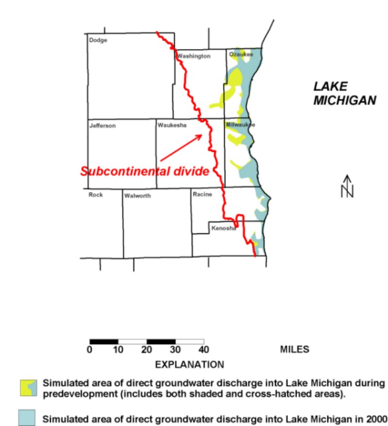
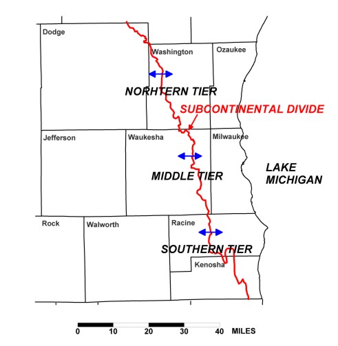
the Lake. All streams east of the subcontinental surface-water divide flow into
Lake Michigan. All the land area east of this watershed divide is part of the
Great Lakes Basin.
First, consider the reduction in direct
ground-water discharge to the Lake:
Note that the area where direct ground-water discharge to the Lake can occur
is much smaller than the area east of the subcontinental watershed divide where
indirect discharge can occur.
The model quantifies the amount of direct ground-water discharge over time.
Under predevelopment conditions it simulates a rate of 13.3 million gallons per
day. In year 2000, it simulates a rate of 12.2 million gallons per day, amounting
to a decrease of over 8%.
Next consider the reduction in indirect discharge to Lake Michigan:
Indirect discharge can be approximated as total of all ground-water discharge
to surface-water bodies within the Great Lakes Basin in southeastern Wisconsin
(it is an approximation because not all water bodies necessarily route water
to Lake Michigan, but it is a fair assumption that most do). The model results
for predevelopment conditions simulate indirect discharge equal to 144.8 million
gallons per day. The corresponding 2000 results are equal to 134.0 million gallons
per day, a reduction of about 7%. Clearly the amount of indirect discharge is
much larger than the amount of direct discharge before and after development.
All these results are summarized in the following table. It also includes
model results for an intermediate period, 1950:
Effect
of Pumping on Rates of Ground-water Interaction with Lake Michigan across
Ozaukee,
Milwaukee, Racine and Kenosha counties. |
[Values
are in million of gallons per day] |
Year |
Pumping East
of Subcontinental Divide |
Direct Discharge
to Lake
Michigan |
Indirect Discharge
to Lake Michigan |
Total Discharge
to Lake Michigan |
1864 |
0 |
13.27 |
144.79 |
158.06 |
1950 |
2.57 |
12.86 |
142.95 |
155.81 |
2000 |
20.18 |
11.76 |
132.88 |
144.64 |
Percent change between
1864 and 2000 |
|
-11.4% |
-8.2% |
-8.5% |
EXPLANATION
- Pumping and discharge fluxes refer to shallow part of flow system only.
- Direct discharge refers to shallow ground-water flow into Lake Michigan.
- Indirect discharge refers to shallow ground-water flow into surface-water bodies
east of the subcontinental divide that empty to Lake Michigan.
- The model simulation accounts for effect of pumping on ground-water discharge
to Lake Michigan, but it does not account account for return flow of pumped water
to the Lake through sewer outfalls in coastal communities. It is not known how
much pumped ground water is returned to the Lake in this way. It is also not
known the extent to which the timing, temperature, and water quality of the return
flow differs from natural discharge to the Lake.
(source: Wisconsin Geological and Natural History Survey
Open-File Report 2004-01) |
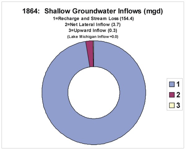
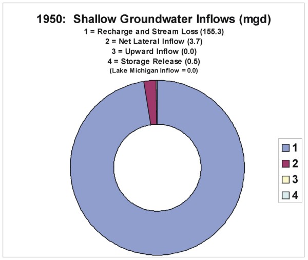
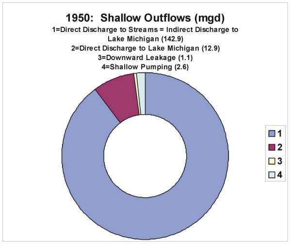
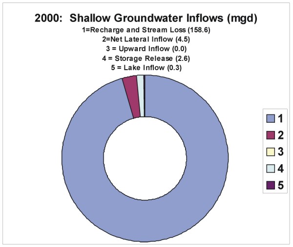
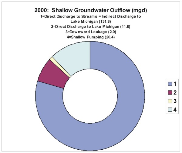
East of the subcontinental divide, pumping has changed
how shallow ground water is replenished and how it is discharged. The pie charts
below show the water balance for the shallow ground-water system through time
for the inland part of the Lake Michigan basin east of the subcontinental divide
in southeastern Wisconsin. The thumbnail charts indicate that while recharge
remains the predominant source of shallow ground water through time, shallow
pumping is now a major sink because it discharges more ground water within the
basin than does direct outflow to the Lake. Note that the inflow and outflow
units in the charts are million gallons per day (mgd).
Model output: |
Model output: |
Shallow Ground-Water INFLOW
Rates Within
Lake Michigan Basin
|
Shallow Ground-water OUTFLOW
Rates Within
Lake Michigan Basin
|
 1864 |
 1864 |
 1950 |
 1950 |
 2000 |
 2000 |
|
(source: D.T. Feinstein, U.S. Geological
Survey)
|
Another way to look at the effect of pumping on
ground-water flow to Lake Michigan is to consider the volumes (rather than the
rates) of water discharged from the land toward the Lake over an interval of
time from both the shallow and deep parts of the flow system. IN THE ABSENCE
OF PUMPING, Lake Michigan and the ground-water system under the lake between
1864 and 2000 would have received the following volume of direct ground-water
discharge in BILLIONS of gallons:
Entire System |
Shallow Part |
Deep Part |
|
711.3 |
562.8 |
148.5 |
WITH PUMPING, Lake Michigan the ground-water system under the lake actually
received or yielded (negative) the following in direct ground-water discharge
between 1864 and 2000:
Entire System |
Shallow Part |
Deep Part |
|
523.7 |
541.6 |
-17.9 |
In other words, between 1864 and 2000 Lake Michigan and the ground-water system
under the Lake along Southeastern Wisconsin has lost the following volume of
water due to the effect of shallow and deep pumping:
Entire System |
Shallow Part |
Deep Part |
|
187.6 |
21.2 |
166.4 |
Note: These estimates of water lost to the Lake do not take account of water
added to the Lake via return flow from sewers and water-treatment plants.
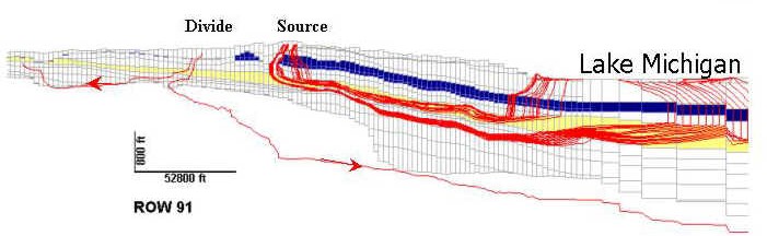
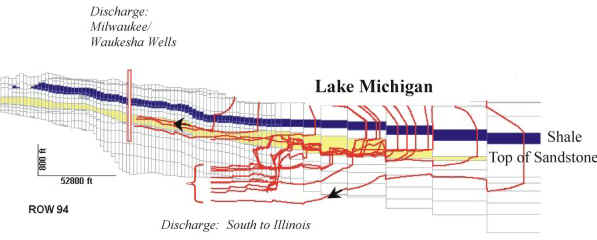
Change in DEEP FLOW PATTERN below Lake Michigan
As pointed out in earlier pages of this website, pumping has reversed the
pattern of deep regional ground-water flow to Lake Michigan:
|
|
NOTE: These simulated
flow lines represent the flow field that would exist if 2000
pumping were to continue for hundreds of years.
|
|
(source: D.T. Feinstein, U.S. Geological Survey)
|
Under predevelopment conditions the model simulates
that 1.9 million gallons per day of ground-water flows upward from the deep to
the shallow part of the flow system and into Lake Michigan over the area of the
Lake between southeastern Wisconsin and Michigan. Under 2000 conditions, the
model simulates that 1.3 million gallons per day flows vertically in the opposite
direction, most of which originates as Lake water. However, part of the 3.2 million
gallons per day difference is due to pumping outside of southeastern Wisconsin,
notably in northeastern Illinois.
SOUTHEASTERN WISCONSIN IN CONTEXT
According to the computer model, the sum of direct and indirect ground-water
discharge to lake from the seven-county area is currently on the order of 145
million gallons per day or 224 cubic feet per second. This amount is a very small
percentage of the total ground-water discharge to Lake Michigan, estimated to
be almost 35,000 cubic feet per second (U.S. Geological Survey Water-Resources
Investigations Report 00-4008). The contribution from southeastern Wisconsin
is so small because the inland portion of the basin is very narrow and, therefore,
receives a lower volume of precipitation than elsewhere within the Lake Michigan
watershed:
The simulated reduction of shallow
direct and indirect ground-water discharge to Lake Michigan between the late
19th century and the year 2000 is on the order of 13 million gallons per day,
equivalent to 21 cubic feet per second, or 8.5% of the predevelopment shallow
ground-water discharge from southeastern Wisconsin. The reduction of ground-water
discharge to adjacent areas of Lake Michigan from deep rocks due to reversals
of gradients is smaller - the model simulates a loss of about 3 million gallons
per day or 5 cubic feet per second. The sum of these reductions, 26 cubic
feet per second, is negligible when taken in context of the overall
budget of the Lake. The total inflow to the Lake (precipitation + surface runoff
+ direct ground - water discharge + indirect ground-water discharge) is estimated
in USGS publications to be about 96,000 cubic feet per second,
a level nearly 4,000 times greater than the loss due to wells. In light of these
numbers it is clear that pumping in southeastern Wisconsin by itself, although
it has had a calculable effect on local hydrologic conditions, has had virtually
no effect on the amount of water in Lake Michigan or on its water level.
In digesting all these results for the effect of pumping on ground-water discharge
to Lake Michigan, it is important to keep in mind an important limitation of
the modeling results. Over time, the recharge rate supplying water to the ground-water
system has probably changed. However, it is very difficult to evaluate this change
because competing forces are at work. Urbanization in southeastern Wisconsin
has brought pavement and parking lots which tend to increase overland runoff
and, consequently, reduce ground-water recharge. On the other hand, there is
evidence across Wisconsin that ground-water discharge to streams is increasing
in many areas, possibly because the soil is freezing later in the year and allowing
more precipitation to percolate as recharge. The net effect of urbanization and
climate change is unknown for any particular region such as the Great Lakes Basin
in southeastern Wisconsin. In the model the recharge rate is kept constant through
time, but if there has, in fact, been a significant increase or decrease in recharge,
then there would have been a corresponding increase or decrease in ground-water
discharge that would either oppose or magnify the simulated effect of pumping.
Another factor neglected by the model is return flow to Lake Michigan from
storm and sanitary sewers and from the Deep Tunnel that underlies Milwaukee.
Part of the water pumped from the shallow and deep parts of the flow system east
of the subcontinental divide is discharged to sewers and routed back to the Lake.
While this return flow offsets part of the decline in ground-water discharge
to the Lake that occurs because of pumping, it also changes the timing, location,
and quality of the discharged water relative to natural conditions.
IS THE MISSISSIPPI RIVER BASIN or THE LAKE MICHIGAN
BASIN THE MAIN SOURCE OF WATER TO DEEP SANDSTONE AQUIFER WELLS IN SOUTHEASERN
WISCONSIN ?
An important conclusion of the modeling study is that the deep wells in southeastern
Wisconsin are located within the Lake Michigan ground-water basin (see the Case
Study section called “Effect
of pumping on ground-water divides in the deep sandstone aquifer in southeastern
Wisconsin”). But because the shallow and deep parts of the flow system
are interconnected, this fact alone does not imply that the water replenishing
the wells comes completely or even mostly from the Lake Michigan Basin.
The majority of the water that replenishes discharge from southeastern Wisconsin
wells originates as captured baseflow - that is water that would have circulated
thru the shallow flow system to streams but is being diverted downward toward
the deep wells. In fact, according to the model, captured baseflow constitutes
59% of the sources of water to deep wells for 2000 pumpage (= 33 mgd). Other
sources include storage release and inflow from the west (e.g., Jefferson County
) and from the east (e.g., from under Lake Michigan).
The question arises - how much of that captured baseflow is captured from
streams in the Mississippi River Basin and
how much from streams within the Lake Michigan Basin. The answer
is that ALMOST ALL diverted baseflow to streams is captured from the Mississippi
River Basin - 9/10 of the captured baseflow to be precise. This is no surprise
because the Maquoketa shale becomes an increasingly powerful obstacle to vertical
flow downward as you move east from the Maquoketa subcrop in western Waukesha
County toward Lake Michigan.
Moreover, according to the model, 18% of the 33 mgd pumped from deep wells
flows into southeastern Wisconsin from the west. Virtually all that amount is
due to capture of baseflow from streams located west of southeastern Wisconsin
but in the Mississippi Basin.
Conclusion : 71% (0.9*59% + 18%) of
the water replenishing discharge from deep wells in southeastern Wisconsin is
ground water diverted from streams (captured baseflow) within the Mississippi
River Basin even though the wells themselves are located in the Lake Michigan
ground-water basin. The remainder, according to the model, is
from captured baseflow in the Lake Michigan Basin (6%), inland storage release
(3%), storage release below Lake Michigan (8%), water that once flow toward rocks
under Lake Michigan (8%) and water flowing out of Lake Michigan itself (only
4%).
It follows that Lake Michigan is NOT the main source
of water to deep wells – for
two reasons. First, water currently discharging from wells is NOT derived
from Lake Michigan but from old water that entered the ground-water system as
recharge in the Mississippi Basin . Second, the source of water that is replenishing the
aquifer water discharged by deep wells is mostly diverted from local streams
in the Mississippi Basin.
While the diversion of streamflow is an important source of water to deep
wells, it produces a small change in the streams themselves. In fact, other factors
such as urbanization and climate variability are more important in determining
changes in streamflow over time, and these other factors mask any measurable
change due to deep pumping.
One final point – most of the water discharged
from the deep well pumping centers is recirculated back to the Mississippi Basin
(net a small amount of loss to evaporation) via water treatment discharge to
the Fox River.
return to top |


