The METAALICUS project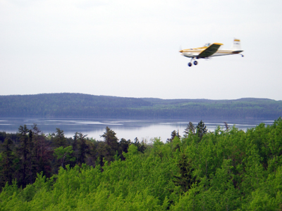
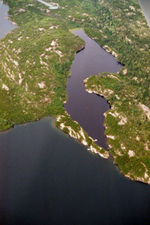
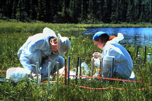
The Mercury Experiment to Assess Atmospheric Loadings in Canada and the US (METAALICUS) project is a unique, whole ecosystem mercury loading study to test the watershed-scale response to a change in mercury load. The project is based out of the Experimental Lakes Area (ELA: http://www.umanitoba.ca/institutes/fisheries/) of Ontario, Canada, where there is a long history of whole-ecosystem manipulation studies. The project is an ambitious effort that has as its overall goal to answer a vexing, policy-relevant question: with centuries of relic mercury contamination already residing in soils and sediments across the globe, will proposed regulations have the intended benefit, and if so, what will be the timing and magnitude of ecosystem response? To answer this question, we combined two unique experimental approaches. First, we manipulated the mercury load for an entire catchment (a lake and its watershed) to examine the response of changes to mercury loadings at the whole-ecosystem scale. Although the amount we added was about 5x current levels near ELA, the amount is not dissimilar to what is currently depositing in the northeastern US (figure of Mercury Additions to Metaalicus watershed), This scale was necessary because mercury works its way through catchments in many steps and over varying time scales, interact with each other in ways that are not completely understood, and cannot be replicated at the laboratory or mesocosm scale. Second, we used enriched stable mercury isotopes as the form of mercury in our loading efforts. This enabled us to follow newly deposited mercury separately from mercury that was already in the catchment. The enriched stable isotopes were applied to the watershed by aerial spraying from an aircraft, whereas the applications to the lake were done out of boat on a every two week basis during the ice-free season. This experiment made it possible to measure the magnitude of change in fish methylmercury concentrations due solely to changes in mercury input and to examine how quickly methylmercury concentrations in fish change in response to alterations in annual mercury loading. Each part of the watershed is dosed with a different mercury isotope (e.g., uplands receive 200Hg; the lake 202Hg; and the wetland 198Hg) so that we can distinguish and quantify the response of the increased load specific to each component of the watershed.
There have been three phases to the METAALICUS project: pre-dosing, or baseline studies; the loading phase, and the recovery phase. In order to provide baseline data to compare against during the loading and recovery phases, the METAALICUS teams studied the experimental watershed (referred to as Lake 658) in 1999 and 2000. The loading phase of the METAALICUS project was conducted for seven years - 2001 through 2007. Since then, the research team has been effectively conducting a new research project – a mercury reduction experiment – whereby we are studying the response to a reduction in load. This two phase nature of this study is important because there is no known information on the relative rates of ecosystem response to increases versus decreases in loads.
 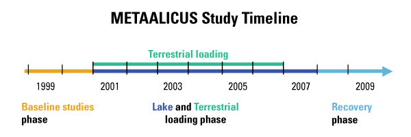
There have been three phases to the METAALICUS project: pre-dosing, or baseline studies; the loading phase, and the recovery phase. In order to provide baseline data to compare against during the loading and recovery phases, the METAALICUS teams studied the experimental watershed (referred to as Lake 658) in 1999 and 2000. The loading phase of the METAALICUS project was conducted for seven years - 2001 through 2007. Since then, the research team has been effectively conducting a new research project – a mercury reduction experiment – whereby we are studying the response to a reduction in load. This two phase nature of this study is important because there is no known information on the relative rates of ecosystem response to increases versus decreases in loads.
Several major findings or outcomes have been derived from the METAALICUS study, which due to the unique approach of the study could not have been derived from any other study. These include: (1) the food web showed a demonstrable and near proportional response to the increase in total ambient mercury loading - atmospheric and watershed contributions – (Harris et al., 2007); (2) unlike the response of the lake, contributions to runoff of the isotope applied to the terrestrial environment had VERY minimal mobility and it took several years loading before the terrestrial applications could be easily seen in runoff flowing into Lake 658 (Hintellmann et al., 2002); and (3) evasion fluxes from the tree canopy and the lake were surprisingly high, and accounted for a major portion of both the aquatic and terrestrial applied mercury loads (Graydon et al., 2006, 2009). Several other plot-scale studies on the METAALICUS project has provided the opportunity to study a mercury tracers in natural settings and make novel discoveries about transport pathways and rates in key settings like wetlands.
|