USGS


    Mercury Research Team Staff :
    • David P. Krabbenhoft
      Team Leader and
      Project Chief
      (608) 821-3843 dpkrabbe@usgs.gov
    • John F. DeWild
      Lab Operations and
      QA Officer
      (608) 821-3846 jfdewild@usgs.gov
    • Jake Ogorek
      Biologist and Chemical Hygiene Officer
      (608) 821-3819 jmogorek@usgs.gov
    • Mike Tate
      Physical Scientist
      Mobile Mercury Lab Operations
      (608) 821-3830 mttate@usgs.gov
    • Ryan Lepak
      Student Trainee (Hydrology)/Lab Assistant
      (608) 821-3819
      rlepak@usgs.gov

USGS IN YOUR STATE

USGS Water Science Centers are located in each state.

There is a USGS Water Science Center office in each State. Washington Oregon California Idaho Nevada Montana Wyoming Utah Colorado Arizona New Mexico North Dakota South Dakota Nebraska Kansas Oklahoma Texas Minnesota Iowa Missouri Arkansas Louisiana Wisconsin Illinois Mississippi Michigan Indiana Ohio Kentucky Tennessee Alabama Pennsylvania West Virginia Georgia Florida Caribbean Alaska Hawaii New York Vermont New Hampshire Maine Massachusetts South Carolina North Carolina Rhode Island Virginia Connecticut New Jersey Maryland-Delaware-D.C.

National Assessment Study of Mercury Contamination of Aquatic Ecosystems

Project Number: xxx
Project Chief: Dave Krabbenhoft
Project Topics: mercury, biogeochemical processes, bioaccumulation
Cooperators: USGS Toxic Substances Hydrology Program; NAWQA
Period of Project: yyyy to present

21 units are participating in the national mercury Pilot StudyIntroduction

This project brings together the expertise of an interdisciplinary team of scientists and programs to execute an integrated monitoring and research plan that will take a holistic approach toward examining mercury cycling and bioaccumulation at a set of NAWQA watersheds across the United States, which exhibit widely ranging ecosystem conditions, mercury sources, and biological components (food webs).

The project employs the combined talents, interests, and funding of scientists from the NAWQA, Toxics, and NRP programs of the Water Resources Discipline, as well as scientists and programs from the Biological Resources Discipline of the USGS.

In essence, this proposal distills the "mercury problem" down to three forcing functions that we believe control mercury toxicity in aquatic ecosystems:

  1. source characterization, apportionment and quantification;
  2. the biogeochemical processes that lead to the formation of methylmercury; and,
  3. the introduction of methylmercury into the food web (bioaccumulation) and biomagnification steps that follow.

These three forcing functions are referred to here as the Mercury Triad. Our overall research objective is to determine what environmental and biological factors govern the methylation of mercury and its resulting bioaccumulation in aquatic ecosystems.

methylmercury by study basin
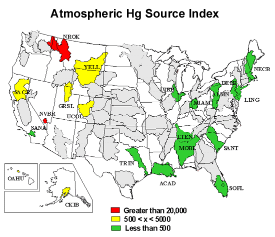
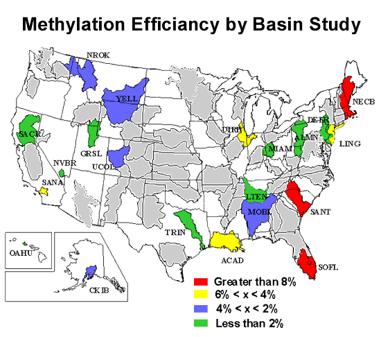
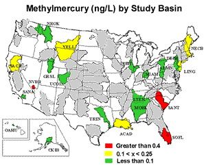
We have identified five NAWQA study basins (CONN, GAFL, WMIC, WILM, and NVBR) that present a unique opportunity to extend the three pieces of the Mercury Triad in such a way that we be able elucidate the relative importance of these forcing functions under varying environmental conditions.

A primary strength of this effort is the adoption of a consistent set of research questions and field and laboratory methods that will be applied to each of the study basins, such that the results will not only be comparable among basins but transferable to other locations in the US.

Problem

Mercury contamination of environment and toxicological exposure to wildlife and humans is a complex problem that is unlike any other contaminant issue mankind has ever been confronted with, and requires a special level of holistic, interdisciplinary research before we will be able to take effective steps toward improving environmental conditions.

atmospheric mercury source indexFirst, it is unique among all known elements in that at ambient pressure and temperature its stable phase is as a metallic liquid that is highly vaporous. Thus, unlike all other heavy metals of general concern, it is effectively distributed in the gaseous state to literally any location, including sensitive ecosystems.

Second, because mercury is an element, releases from both natural and anthropogenic sources are difficult to discriminate and mutually accumulate in various pools in the environment (primarily soils and sediments) where unlike most other contaminants of widespread concern it does not degrade over time and potentially presents a contamination problem for very long periods of time.

Third, unlike most contaminants where biogeochemical processes generally serve to moderate its expressed toxicity, several key natural processes actually served to exacerbate mercury toxicity by converting it to methylmercury, a highly potent neurotoxin that is the focus of most environmental mercury research today. In fact, if mercury were not methylated in the environment, there essentially would be no mercury problem, and as such the "mercury problem" is really a "methylmercury problem".

Mercury methylation is the net result of a vexing series of physical, chemical and microbiological processes, which in an unfortunate twist originate at or near the base of food webs in aquatic ecosystems and effectively serve to "inject" it into the food web from the point of orgination. Although mercury methylation is the focus of intense research currently, it is still poorly understood especially at the national scale.

methylation efficiancy by study basinThe challenge currently confronting resource managers, lawmakers, and the scientific community at large is to bring this complex problem into a more complete understanding that will allow for the proper and responsible actions to not only reduce new releases to the environment, but also prescribe effective land management strategies to deal with existing inventories.

Objectives

Objectives of this study are to:

  1. Evaluate if trends in mercury accumulation and methylmercury production can be identified at national and regional scales across the United States
  2. To identify ecosystem characteristics that favor the production and bioaccumulation of methylmercury.
  3. Study design looks at a national scope with emphasis on multimedia sample collection (water, sediment, and predator fish) with consistent use of trace metal clean sampling methods and low-level mercury and methylmercury analytical procedures.


Accessibility FOIA Privacy Policies and Notices

Take Pride in America logo USA.gov logo U.S. Department of the Interior | U.S. Geological Survey
URL: http://wi.water.usgs.gov/mercury/national-mcae.html
Contact Webmaster
Page Last Modified: Thursday, 10-Jan-2013 11:52:17 EST

05398000: Flow=1530cfs,Stage=13.00ft,Floodstage=25ft,2024-02-26 17:00,<10,WISCONSIN RIVER AT ROTHSCHILD, WI 05391000: Flow=421cfs,Stage=1.43ft,Floodstage=6ft,2024-02-26 17:00,<10,WISCONSIN RIVER @ RAINBOW LAKE NR LAKE TOMAHAWK,WI 05427718: Flow=7.46cfs,Stage=1.08ft,Floodstage=8ft,2024-02-26 17:00,<10,YAHARA RIVER AT WINDSOR, WI 05429500: Flow=307cfs,2024-02-26 16:55,Stage=3.19ft,2024-02-26 17:10:00,76-90,YAHARA RIVER AT MC FARLAND, WI 05404000: Flow=6540cfs,Stage=3.85ft,Floodstage=16ft,2024-02-26 17:00,76-90,WISCONSIN RIVER NEAR WISCONSIN DELLS, WI 05344500: Flow=12800cfs,2024-02-26 16:55,Stage=25.36ft,2024-02-26 17:15:00,76-90,MISSISSIPPI RIVER AT PRESCOTT, WI 05340500: Flow=2800cfs,Stage=3.27ft,2024-02-26 17:00,76-90,ST. CROIX RIVER AT ST. CROIX FALLS, WI 04082400: Flow=4340cfs,Stage=4.86ft,Floodstage=7.5ft,2024-02-26 17:00,76-90,FOX RIVER AT OSHKOSH, WI 04062000: Flow=193cfs,Stage=3.11ft,2024-02-26 17:30,76-90,PAINT RIVER NEAR ALPHA, MI 05544200: Flow=31.7cfs,Stage=2.33ft,Floodstage=5ft,2024-02-26 17:00,10-24,MUKWONAGO RIVER AT MUKWONAGO, WI 05527950: Flow=30.2cfs,Stage=6.76ft,Floodstage=11ft,2024-02-26 17:00,10-24,MILL CREEK AT OLD MILL CREEK, IL 05425912: Flow=49.9cfs,Stage=839.30ft,Floodstage=843.5ft,2024-02-26 17:00,10-24,BEAVERDAM RIVER AT BEAVER DAM, WI 05395000: Flow=1230cfs,Stage=4.19ft,Floodstage=11ft,2024-02-26 17:10,10-24,WISCONSIN RIVER AT MERRILL, WI 05389400: Flow=13.4cfs,Stage=5.19ft,2024-02-26 17:00,10-24,Bloody Run Creek near Marquette, IA 04087159: Flow=5.91cfs,Stage=6.14ft,Floodstage=16ft,2024-02-26 17:00,10-24,KINNICKINNIC RIVER @ S. 11TH STREET @ MILWAUKEE,WI 04027500: Flow=165cfs,Stage=0.72ft,2024-02-26 17:35,10-24,WHITE RIVER NEAR ASHLAND, WI 05548280: Flow=110cfs,Stage=4.30ft,Floodstage=11ft,2024-02-26 17:00,25-75,NIPPERSINK CREEK NEAR SPRING GROVE, IL 05543830: Flow=119cfs,Stage=3.26ft,Floodstage=6ft,2024-02-26 17:00,25-75,FOX RIVER AT WAUKESHA, WI 05527800: Flow=64.3cfs,Stage=3.05ft,Floodstage=7ft,2024-02-26 17:30,25-75,DES PLAINES RIVER AT RUSSELL, IL 05438283: Flow=1.70cfs,Stage=5.48ft,2024-02-26 17:00,25-75,PISCASAW CREEK NEAR WALWORTH, WI 05437500: Flow=4270cfs,Stage=4.62ft,Floodstage=10ft,2024-02-26 17:30,25-75,ROCK RIVER AT ROCKTON, IL 05437050: Flow=1530cfs,Stage=5.33ft,Floodstage=12ft,2024-02-26 17:00,25-75,PECATONICA RIVER NR SHIRLAND, ILL 05436500: Flow=324cfs,Stage=1.17ft,Floodstage=5ft,2024-02-26 17:00,25-75,SUGAR RIVER NEAR BRODHEAD, WI 05434500: Flow=611cfs,Stage=5.69ft,Floodstage=13.5ft,2024-02-26 17:00,25-75,PECATONICA RIVER AT MARTINTOWN, WI 05433000: Flow=140cfs,Stage=4.49ft,Floodstage=11ft,2024-02-26 17:00,25-75,EAST BRANCH PECATONICA RIVER NR BLANCHARDVILLE, WI 05432500: Flow=152cfs,Stage=2.68ft,Floodstage=13.5ft,2024-02-26 17:00,25-75,PECATONICA RIVER AT DARLINGTON, WI 05431486: Flow=116cfs,Stage=3.81ft,Floodstage=8ft,2024-02-26 17:00,25-75,TURTLE CREEK AT CARVERS ROCK ROAD NEAR CLINTON, WI 05430500: Flow=2200cfs,Stage=4.97ft,Floodstage=9ft,2024-02-26 17:00,25-75,ROCK RIVER AT AFTON, WI 05430175: Flow=362cfs,Stage=4.57ft,Floodstage=10ft,2024-02-26 17:00,25-75,YAHARA RIVER NEAR FULTON, WI 05430150: Flow=95.7cfs,Stage=4.96ft,2024-02-26 17:00,25-75,BADFISH CREEK NEAR COOKSVILLE, WI 05427965: Flow=0.22cfs,Stage=0.43ft,2024-02-26 17:00,25-75,SPRING HARBOR STORM SEWER AT MADISON, WI 05427948: Flow=2.45cfs,Stage=3.43ft,2024-02-26 17:00,25-75,PHEASANT BRANCH AT MIDDLETON, WI 05426250: Flow=87.0cfs,Stage=2.27ft,Floodstage=4ft,2024-02-26 17:00,25-75,BARK RIVER NEAR ROME, WI 05426000: Flow=346cfs,Stage=2.60ft,Floodstage=7ft,2024-02-26 17:00,25-75,CRAWFISH RIVER AT MILFORD, WI 05425500: Flow=748cfs,Stage=2.51ft,Floodstage=5.5ft,2024-02-26 17:00,25-75,ROCK RIVER AT WATERTOWN, WI 05423500: Flow=13.0cfs,Stage=2.12ft,Floodstage=6ft,2024-02-26 17:00,25-75,SOUTH BRANCH ROCK RIVER AT WAUPUN, WI 05414000: Flow=66.9cfs,Stage=3.76ft,Floodstage=9ft,2024-02-26 17:15,25-75,PLATTE RIVER NEAR ROCKVILLE, WI 05413500: Flow=132cfs,Stage=4.89ft,Floodstage=18ft,2024-02-26 17:15,25-75,GRANT RIVER AT BURTON, WI 05410490: Flow=444cfs,Stage=6.31ft,Floodstage=12ft,2024-02-26 17:45,25-75,KICKAPOO RIVER AT STEUBEN, WI 05407000: Flow=8030cfs,Stage=2.01ft,Floodstage=9ft,2024-02-26 17:00,25-75,WISCONSIN RIVER AT MUSCODA, WI 05406500: Flow=37.9cfs,Stage=2.14ft,Floodstage=5.5ft,2024-02-26 17:00,25-75,BLACK EARTH CREEK AT BLACK EARTH, WI 05403500: Flow=304cfs,Stage=4.00ft,Floodstage=10ft,2024-02-26 17:00,25-75,LEMONWEIR RIVER AT NEW LISBON, WI 05401050: Flow=49.4cfs,Stage=4.74ft,Floodstage=9.5ft,2024-02-26 17:00,25-75,TENMILE CREEK NEAR NEKOOSA, WI 05400760: Flow=2730cfs,2024-02-26 17:00,Stage=2.73ft,2024-02-26 17:30:00,Floodstage=12.00ft,25-75,WISCONSIN RIVER AT WISCONSIN RAPIDS, WI 05394500: Flow=101cfs,Stage=2.19ft,Floodstage=7ft,2024-02-26 17:00,25-75,PRAIRIE RIVER NEAR MERRILL, WI 05389000: Flow=64.8cfs,Stage=5.46ft,2024-02-26 17:45,25-75,Yellow River near Ion, IA 05382000: Flow=782cfs,Stage=3.67ft,Floodstage=12ft,2024-02-26 17:00,25-75,BLACK RIVER NEAR GALESVILLE, WI 05379500: Flow=389cfs,Stage=5.37ft,Floodstage=10.5ft,2024-02-26 16:15,25-75,TREMPEALEAU RIVER AT DODGE, WI 05370000: Flow=18.7cfs,Stage=12.27ft,2024-02-26 17:45,25-75,EAU GALLE RIVER AT SPRING VALLEY, WI 05369500: Flow=4500cfs,Stage=2.93ft,Floodstage=13ft,2024-02-26 17:00,25-75,CHIPPEWA RIVER AT DURAND, WI 05369000: Flow=989cfs,Stage=6.54ft,2024-02-26 17:00,25-75,RED CEDAR RIVER AT MENOMONIE, WI 05368000: Flow=234cfs,Stage=3.69ft,2024-02-26 17:00,25-75,HAY RIVER AT WHEELER, WI 05367500: Flow=656cfs,Stage=2.53ft,2024-02-26 17:00,25-75,RED CEDAR RIVER NEAR COLFAX, WI 05365500: Flow=2280cfs,Stage=3.55ft,2024-02-26 17:05,25-75,CHIPPEWA RIVER AT CHIPPEWA FALLS, WI 05360500: Flow=939cfs,Stage=5.62ft,2024-02-26 17:05,25-75,FLAMBEAU RIVER NEAR BRUCE, WI 05356500: Flow=713cfs,Stage=2.04ft,2024-02-26 17:00,25-75,CHIPPEWA RIVER NEAR BRUCE, WI 05356000: Flow=485cfs,Stage=4.76ft,Floodstage=11ft,2024-02-26 17:00,25-75,CHIPPEWA RIVER AT BISHOPS BRIDGE NEAR WINTER, WI 05333500: Flow=1050cfs,Stage=1.07ft,Floodstage=7ft,2024-02-26 17:00,25-75,ST. CROIX RIVER NEAR DANBURY, WI 04087257: Flow=31.0cfs,Stage=1.57ft,2024-02-26 17:00,25-75,PIKE RIVER NEAR RACINE, WI 04087240: Flow=96.5cfs,Stage=2.88ft,Floodstage=7ft,2024-02-26 17:00,25-75,ROOT RIVER AT RACINE, WI 04087233: Flow=28.0cfs,Stage=2.64ft,Floodstage=9ft,2024-02-26 17:00,25-75,ROOT RIVER CANAL NEAR FRANKLIN, WI 04087220: Flow=21.9cfs,Stage=2.27ft,Floodstage=8ft,2024-02-26 17:00,25-75,ROOT RIVER NEAR FRANKLIN, WI 04087204: Flow=16.8cfs,Stage=2.60ft,Floodstage=8ft,2024-02-26 17:00,25-75,OAK CREEK AT SOUTH MILWAUKEE, WI 04087120: Flow=86.4cfs,Stage=2.14ft,Floodstage=11ft,2024-02-26 16:55,25-75,MENOMONEE RIVER AT WAUWATOSA, WI 04087088: Flow=8.04cfs,Stage=8.34ft,2024-02-26 17:00,25-75,UNDERWOOD CREEK AT WAUWATOSA, WI 04087030: Flow=32.7cfs,Stage=3.52ft,Floodstage=7.5ft,2024-02-26 16:30,25-75,MENOMONEE RIVER AT MENOMONEE FALLS, WI 04087000: Flow=607cfs,Stage=2.54ft,Floodstage=7ft,2024-02-26 16:30,25-75,MILWAUKEE RIVER AT MILWAUKEE, WI 04086600: Flow=569cfs,Stage=6.43ft,Floodstage=11ft,2024-02-26 17:00,25-75,MILWAUKEE RIVER NEAR CEDARBURG, WI 04086500: Flow=102cfs,Stage=5.88ft,Floodstage=10ft,2024-02-26 17:15,25-75,CEDAR CREEK NEAR CEDARBURG, WI 04086000: Flow=295cfs,Stage=2.58ft,Floodstage=8ft,2024-02-26 17:00,25-75,SHEBOYGAN RIVER AT SHEBOYGAN, WI 04084445: Flow=3980cfs,Stage=5.75ft,Floodstage=8.4ft,2024-02-26 17:00,25-75,FOX RIVER AT APPLETON, WI 04078500: Flow=192cfs,Stage=2.92ft,Floodstage=7ft,2024-02-26 17:00,25-75,EMBARRASS RIVER NEAR EMBARRASS, WI 04077630: Flow=113cfs,Stage=5.86ft,Floodstage=11ft,2024-02-26 17:00,25-75,RED RIVER AT MORGAN ROAD NEAR MORGAN, WI 04073500: Flow=840cfs,Stage=8.98ft,Floodstage=13ft,2024-02-26 17:00,25-75,FOX RIVER AT BERLIN, WI 04071000: Flow=403cfs,Stage=1.23ft,Floodstage=7.5ft,2024-02-26 17:00,25-75,OCONTO RIVER NEAR GILLETT, WI 04069500: Flow=528cfs,Stage=1.57ft,Floodstage=10ft,2024-02-26 17:00,25-75,PESHTIGO RIVER AT PESHTIGO, WI 04064500: Flow=211cfs,Stage=1.99ft,Floodstage=7ft,2024-02-26 16:45,25-75,PINE RIVER BELOW PINE R POWERPLANT NR FLORENCE, WI 04063700: Flow=35.5cfs,Stage=1.95ft,Floodstage=6ft,2024-02-26 17:45,25-75,POPPLE RIVER NEAR FENCE, WI 04063000: Flow=1610cfs,Stage=4.28ft,Floodstage=9ft,2024-02-26 17:00,25-75,MENOMINEE RIVER NEAR FLORENCE, WI 04062011: Flow=442cfs,Stage=6.88ft,Floodstage=12ft,2024-02-26 17:30,25-75,BRULE RIVER NEAR COMMONWEALTH, WI 04060500: Flow=60.9cfs,Stage=4.07ft,Floodstage=11ft,2024-02-26 17:30,25-75,IRON RIVER AT CASPIAN, MI 04037500: Flow=41.4cfs,Stage=4.66ft,2024-02-26 17:00,25-75,CISCO BRANCH ONTONAGON R AT CISCO LAKE OUTLET, MI 04025500: Flow=138cfs,Stage=1.61ft,2024-02-26 17:00,25-75,BOIS BRULE RIVER AT BRULE, WI 463741090521301: Stage=601.78ft,2024-02-26 17:00,Not ranked,ASHLAND BREAKWATER LIGHTHOUSE CHEQUAMEGON BAY, WI 445322088281801: Stage=92.62ft,2024-02-26 17:00,Not ranked,BERRY LAKE NEAR SHAWANO, WI 442119088085501: Flow=0.0000cfs,Stage=0.00ft,2024-02-26 17:00,Not ranked,GLRI WATERWAY NUMBER 4 NR WRIGHTSTOWN, WI 442114088085701: Flow=0.0105cfs,Stage=0.04ft,2024-02-26 17:00,Not ranked,GLRI WATERWAY NUMBER 5 NR WRIGHTSTOWN, WI 441520088045001: Flow=0.0000cfs,Stage=-0.01ft,2024-02-26 17:00,Not ranked,GLRI EAST RIVER WATERWAY 3 NEAR GREENLEAF, WI 425715089164700: Stage=2.27ft,2024-02-26 17:00,Not ranked,LAKE KEGONSA AT BARBER DRIVE NEAR STOUGHTON, WI 424848088083100: Stage=7.76ft,2024-02-26 17:15,Not ranked,WIND LAKE AT OUTLET AT WIND LAKE, WI 423525088260400: Stage=2.50ft,2024-02-26 13:00,Not ranked,GENEVA LAKE AT LAKE GENEVA, WI 055451345: Flow=26.6cfs,2024-02-26 16:00,Stage=8.15ft,2024-02-26 16:55:00,Not ranked,WHITE RIVER AT CENTER STREET AT LAKE GENEVA, WI 054279465: Flow=0.04cfs,Stage=2.00ft,2024-02-26 17:00,Not ranked,S FORK PHEASANT BRANCH @ DEMING WAY @ MIDDLETON,WI 054041665: Flow=194cfs,Stage=5.58ft,Floodstage=14ft,2024-02-26 17:00,Not ranked,BARABOO RIVER AT MAIN STREET AT REEDSBURG, WI 053813595: Flow=495cfs,Stage=36.35ft,Floodstage=47ft,2024-02-26 17:00,Not ranked,BLACK RIVER DS ST HWY 54 AT BLACK RIVER FALLS, WI 040871488: Flow=3.73cfs,Stage=11.14ft,2024-02-26 17:25,Not ranked,WILSON PARK CK @ ST. LUKES HOSPITAL @ MILWAUKEE,WI 040871476: Flow=0.00cfs,Stage=0.10ft,2024-02-26 17:00,Not ranked,HOLMES AVE CRK TRIB @ GMIA OUTFALL 1 AT MILWAUKEE 040871475: Flow=1.07cfs,Stage=10.92ft,2024-02-26 17:20,Not ranked,WILSON PARK CREEK @ GMIA OUTFALL 7 @ MILWAUKEE,WI 040871473: Flow=0.21cfs,Stage=10.65ft,2024-02-26 17:10,Not ranked,WILSON PARK CREEK AT GMIA INFALL AT MILWAUKEE, WI 040869416: Flow=4.56cfs,Stage=3.65ft,2024-02-26 17:05,Not ranked,LINCOLN CREEK @ SHERMAN BOULEVARD AT MILWAUKEE, WI 040851385: Flow=-934cfs,Stage=578.85ft,Floodstage=584ft,2024-02-26 17:20,Not ranked,FOX RIVER AT OIL TANK DEPOT AT GREEN BAY, WI 040734605: Flow=-36.8cfs,Stage=6.12ft,2024-02-26 17:00,Not ranked,GREEN LAKE SW INLET @ CT HIGHWY K NR GREEN LAKE,WI 040263205: Flow=19.8cfs,Stage=2.11ft,2024-02-26 17:05,Not ranked,WHITTLESEY CREEK NEAR ASHLAND, WI 05548000: Stage=2.45ft,Floodstage=6ft,2024-02-26 17:00,Not ranked,NIPPERSINK LAKE AT FOX LAKE, IL 05547500: Stage=2.50ft,Floodstage=6ft,2024-02-26 17:30,Not ranked,FOX LAKE NEAR LAKE VILLA, IL 05547000: Stage=2.95ft,Floodstage=6ft,2024-02-26 17:45,Not ranked,CHANNEL LAKE NEAR ANTIOCH, IL 05545750: Flow=566cfs,Stage=6.702ft,Floodstage=11ft,2024-02-26 17:00,Not ranked,FOX RIVER NEAR NEW MUNSTER, WI 05544475: Stage=4.50ft,Floodstage=6ft,2024-02-26 17:45,Not ranked,FOX RIVER AT ROCHESTER, WI 05544385: Stage=11.65ft,2024-02-26 17:45,Not ranked,MUSKEGO (BIG MUSKEGO) LAKE OUTLET NR WIND LAKE, WI 05544348: Stage=1.70ft,2024-02-26 17:45,Not ranked,FOX RIVER AT WATERFORD DAM, AT WATERFORD, WI 05435950: Flow=45.7cfs,Stage=2.98ft,2024-02-26 17:00,Not ranked,SUGAR RIVER NEAR VERONA, WI 05435943: Flow=9.17cfs,Stage=4.23ft,2024-02-26 17:00,Not ranked,BADGER MILL CREEK AT VERONA, WI 05431022: Flow=0.38cfs,Stage=5.17ft,2024-02-26 17:00,Not ranked,DELAVAN LAKE OUTLET AT BORG ROAD NEAR DELAVAN, WI 05431016: Flow=10.9cfs,Stage=8.55ft,2024-02-26 17:00,Not ranked,JACKSON CREEK AT MOUND ROAD NEAR ELKHORN, WI 05429700: Flow=216cfs,Stage=6.68ft,2024-02-26 17:00,Not ranked,YAHARA RIVER @ FORTON STREET BRIDGE @ STOUGHTON,WI 05429485: Stage=3.42ft,2024-02-26 17:10,Not ranked,LAKE WAUBESA AT MC FARLAND, WI 05429000: Stage=3.62ft,2024-02-26 17:00,Not ranked,LAKE MONONA AT MADISON, WI 05428500: Flow=87.8cfs,Stage=3.86ft,2024-02-26 17:00,Not ranked,YAHARA RIVER AT EAST MAIN STREET AT MADISON, WI 05428000: Stage=8.93ft,2024-02-26 17:00,Not ranked,LAKE MENDOTA AT MADISON, WI 05427943: Flow=4.10cfs,Stage=4.13ft,2024-02-26 17:00,Not ranked,PHEASANT BRANCH AT AIRPORT ROAD NEAR MIDDLETON, WI 05427930: Flow=6.08cfs,Stage=9.73ft,2024-02-26 17:00,Not ranked,DORN (SPRING) CREEK AT CT HIGHWAY M NR WAUNAKEE,WI 05427927: Flow=5.54cfs,Stage=0.34ft,2024-02-26 17:00,Not ranked,DORN (SPRING) CREEK @ CT HIGHWAY Q NR WAUNAKEE, WI 05427910: Flow=32.3cfs,Stage=9.12ft,2024-02-26 17:00,Not ranked,SIXMILE CREEK @ COUNTY TRNK HGHWY M NR WAUNAKEE,WI 05427880: Flow=11.4cfs,Stage=2.39ft,2024-02-26 17:00,Not ranked,SIXMILE CREEK AT STATE HIGHWAY 19 NEAR WAUNAKEE,WI 05427850: Flow=-0.30cfs,Stage=9.01ft,2024-02-26 17:00,Not ranked,YAHARA RIVER AT STATE HIGHWAY 113 AT MADISON, WI 05427530: Flow=1100cfs,Stage=2.29ft,Floodstage=6.5ft,2024-02-26 17:00,Not ranked,ROCK RIVER AT NEWVILLE, WI 05427235: Stage=5.93ft,Floodstage=10ft,2024-02-26 17:00,Not ranked,LAKE KOSHKONONG NEAR NEWVILLE, WI 05427085: Flow=1610cfs,Stage=11.13ft,Floodstage=16ft,2024-02-26 17:00,Not ranked,ROCK RIVER AT FORT ATKINSON, WI 05426067: Flow=24.6cfs,Stage=12.56ft,2024-02-26 17:00,Not ranked,BARK RIVER AT NAGAWICKA ROAD AT DELAFIELD, WI 05426031: Stage=4.49ft,Floodstage=10ft,2024-02-26 15:45,Not ranked,ROCK RIVER AT JEFFERSON, WI 05424057: Flow=205cfs,Stage=6.37ft,2024-02-26 17:00,Not ranked,ROCK RIVER AT HORICON, WI 05414820: Stage=4.49ft,2024-02-26 17:15:00,Not ranked,Ice affected,SINSINAWA RIVER NEAR MENOMINEE, IL 05414213: Flow=2120cfs,2023-10-14 05:00,Not ranked,LITTLE PLATTE RIVER NEAR PLATTEVILLE, WI 05411500: Stage=11.69ft,2024-02-26 17:45,Not ranked,Mississippi River at Clayton, IA 05408000: Stage=3.12ft,2024-02-26 17:00:00,Floodstage=12ft,Not ranked,Ice affected,KICKAPOO RIVER AT LA FARGE, WI 05407468: Stage=8.57ft,2024-02-26 17:00:00,Floodstage=16ft,Not ranked,Ice affected,KICKAPOO R @ ST HWY 131 AT ONTARIO, WI 05406479: Flow=19.9cfs,Stage=2.70ft,2024-02-26 17:00,Not ranked,BLACK EARTH CK NR TREATMENT PLNT @ CROSS PLAINS,WI 05406469: Flow=2.27cfs,Stage=2.17ft,2024-02-26 17:00,Not ranked,BREWERY CREEK-UPSTREAM SITE-AT CROSS PLAINS, WI 05406457: Flow=13.6cfs,Stage=2.05ft,2024-02-26 17:00,Not ranked,BLACK EARTH CREEK NR BREWERY RD AT CROSS PLAINS,WI 05405000: Stage=7.81ft,2024-02-26 17:00:00,Floodstage=16ft,Not ranked,Ice affected,BARABOO RIVER NEAR BARABOO, WI 05404500: Stage=6.48ft,2024-02-26 17:00,Not ranked,DEVILS LAKE NEAR BARABOO, WI 05404129: Stage=5.95ft,Floodstage=15ft,2024-02-26 17:00,Not ranked,BARABOO RIVER AT LA VALLE, WI 05403000: Flow=220cfs,Stage=9.91ft,Floodstage=15ft,2024-02-26 17:00,Not ranked,YELLOW RIVER AT NECEDAH, WI 05402000: Stage=2.23ft,2024-02-26 17:00:00,Floodstage=12ft,Not ranked,Ice affected,YELLOW RIVER AT BABCOCK, WI 05401514: Flow=15.5cfs,Stage=4.52ft,2024-02-26 17:00,Not ranked,BIG ROCHE A CRI CREEK AT HWY G NR LEOLA, WI 05401063: Stage=95.36ft,2024-02-26 17:00,Not ranked,LAKE HURON NEAR PLAINFIELD, WI 05401034: Flow=5.53cfs,Stage=3.21ft,2024-02-26 17:00,Not ranked,S.BR.TENMILE CREEK NEAR BANCROFT, WI 05400625: Flow=4.55cfs,Stage=3.13ft,2024-02-26 17:00,Not ranked,LITTLE PLOVER RIVER NEAR PLOVER, WI 05399500: Stage=1.94ft,2024-02-26 17:00:00,Floodstage=15.5ft,Not ranked,Ice affected,BIG EAU PLEINE RIVER AT STRATFORD, WI 05397500: Stage=0.56ft,2024-02-26 17:00:00,Floodstage=9ft,Not ranked,Ice affected,EAU CLAIRE RIVER AT KELLY, WI 05396000: Stage=2.30ft,2024-02-26 17:00:00,Floodstage=10ft,Not ranked,Ice affected,BIG RIB RIVER AT RIB FALLS, WI 05393500: Stage=1.55ft,2024-02-26 17:30:00,Floodstage=8ft,Not ranked,Ice affected,SPIRIT RIVER AT SPIRIT FALLS, WI 05390500: Stage=93.27ft,2024-02-26 17:30,Not ranked,ANVIL LAKE NEAR EAGLE RIVER, WI 05390100: Stage=79.48ft,2024-02-26 16:45,Not ranked,LAC VIEUX DESERT NEAR LAND O\'LAKES, WI 05389500: Stage=7.57ft,Floodstage=16ft,2024-02-26 17:45,Not ranked,Mississippi River at McGregor, IA 05386400: Stage=30.94ft,2024-02-26 17:45,Not ranked,MISSISSIPPI RIVER AT BROWNSVILLE, MN 05383075: Flow=318cfs,Stage=2.50ft,Floodstage=7.5ft,2024-02-26 17:00,Not ranked,LA CROSSE RIVER NEAR LA CROSSE, WI 05382325: Flow=143cfs,Stage=3.57ft,Floodstage=8.5ft,2024-02-26 17:15,Not ranked,LA CROSSE RIVER AT SPARTA, WI 05382284: Stage=5.77ft,2024-02-26 16:45:00,Not ranked,Ice affected,SILVER CREEK AT STATE HIGHWAY 21 NEAR ANGELO, WI 05382267: Stage=5.86ft,2024-02-26 17:00:00,Floodstage=11ft,Not ranked,Ice affected,LA CROSSE RIVER @ CNTY TRUNK HIGHWY BB NR TOMAH,WI 05382257: Flow=0.86cfs,Stage=1.64ft,2024-02-26 17:00,Not ranked,STILLWELL CREEK AT YARD ROAD NEAR TOMAH, WI 05382255: Stage=1.28ft,2024-02-26 17:00:00,Not ranked,Ice affected,STILLWELL CREEK AT SIXTEENTH COURT NEAR TOMAH, WI 05381000: Stage=3.35ft,2024-02-26 17:00:00,Floodstage=18ft,Not ranked,Ice affected,BLACK RIVER AT NEILLSVILLE, WI 05379400: Flow=317cfs,Stage=3.34ft,Floodstage=8ft,2024-02-26 17:00,Not ranked,TREMPEALEAU RIVER AT ARCADIA, WI 05378500: Stage=5.71ft,2024-02-26 17:45:00,Floodstage=13ft,Not ranked,Ice affected,MISSISSIPPI RIVER AT WINONA, MN 05378490: Stage=5.97ft,Floodstage=655ft,2024-02-26 17:15,Not ranked,MISSISSIPPI RIVER AT LOCK AND DAM 5A NR WINONA, MN 05366800: Flow=2780cfs,Stage=4.19ft,Floodstage=773ft,2024-02-26 17:00,Not ranked,CHIPPEWA R AT GRAND AVE AT EAU CLAIRE, WI 05365550: Flow=2450cfs,Stage=4.77ft,2024-02-26 17:00,Not ranked,CHIPPEWA RIVER BELOW DELLS DAM AT EAU CLAIRE, WI 05362000: Stage=3.47ft,2024-02-26 17:00:00,Not ranked,Ice affected,JUMP RIVER AT SHELDON, WI 05359500: Stage=4.98ft,2024-02-26 17:45:00,Not ranked,Ice affected,SOUTH FORK FLAMBEAU RIVER NEAR PHILLIPS, WI 05357335: Flow=24.4cfs,Stage=3.26ft,2024-02-26 17:15,Not ranked,BEAR RIVER NEAR MANITOWISH WATERS, WI 05344490: Flow=3650cfs,Stage=25.36ft,2024-02-26 17:15,Not ranked,ST. CROIX RIVER AT PRESCOTT, WI 05342000: Flow=91.8cfs,Stage=8.18ft,2024-02-26 17:30,Not ranked,KINNICKINNIC RIVER NEAR RIVER FALLS, WI 05331833: Flow=90.0cfs,Stage=1.69ft,2024-02-26 17:00,Not ranked,NAMEKAGON RIVER AT LEONARDS, WI 04087234: Flow=88.3cfs,Stage=4.82ft,2024-02-26 17:00,Not ranked,ROOT RIVER AT 60TH ST NEAR CALEDONIA, WI 04087214: Flow=5.94cfs,Stage=10.72ft,2024-02-26 17:00,Not ranked,ROOT RIVER AT GRANGE AVENUE AT GREENDALE, WI 04087170: Flow=2430cfs,Stage=8.58ft,2024-02-26 17:00,Not ranked,MILWAUKEE RIVER AT MOUTH AT MILWAUKEE, WI 04087142: Flow=-68.6cfs,Stage=12.92ft,2024-02-26 17:00,Not ranked,MENOMONEE RIVER AT 16TH STREET AT MILWAUKEE, WI 04087119: Flow=4.82cfs,Stage=9.94ft,2024-02-26 17:00,Not ranked,HONEY CREEK AT WAUWATOSA, WI 04087070: Flow=14.2cfs,Stage=4.06ft,2024-02-26 17:00,Not ranked,LITTLE MENOMONEE RIVER AT MILWAUKEE, WI 04087050: Flow=6.95cfs,Stage=2.34ft,2024-02-26 17:00,Not ranked,LITTLE MENOMONEE RIVER NEAR FREISTADT, WI 04085427: Stage=4.87ft,2024-02-26 17:00:00,Floodstage=10ft,Not ranked,Ice affected,MANITOWOC RIVER AT MANITOWOC, WI 04085200: Stage=9.08ft,2024-02-26 17:00:00,Floodstage=14ft,Not ranked,Ice affected,KEWAUNEE RIVER NEAR KEWAUNEE, WI 04085108: Stage=4.93ft,2024-02-26 17:05:00,Floodstage=13ft,Not ranked,Ice affected,EAST RIVER @ CNTY TRUNK HIGHWAY ZZ NR GREENLEAF,WI 04085068: Flow=0.29cfs,Stage=3.07ft,2024-02-26 17:00,Not ranked,ASHWAUBENON CREEK NEAR LITTLE RAPIDS, WI 04084911: Stage=2.41ft,2024-02-26 17:00:00,Not ranked,Ice affected,PLUM CREEK NEAR WRIGHTSTOWN, WI 04084255: Stage=1.35ft,Floodstage=6ft,2024-02-26 17:00,Not ranked,LAKE WINNEBAGO NEAR STOCKBRIDGE, WI 04083545: Flow=70.6cfs,Stage=1.62ft,2024-02-26 17:00,Not ranked,FOND DU LAC RIVER @ W. ARNDT ST. AT FOND DU LAC,WI 04082500: Stage=1.45ft,Floodstage=3.7ft,2024-02-26 17:00,Not ranked,LAKE WINNEBAGO AT OSHKOSH, WI 04080798: Flow=24.7cfs,Stage=8.52ft,2024-02-26 17:00,Not ranked,TOMORROW RIVER NEAR NELSONVILLE, WI 04079000: Stage=2.07ft,2024-02-26 17:00:00,Floodstage=9ft,Not ranked,Ice affected,WOLF RIVER AT NEW LONDON, WI 04074950: Stage=7.79ft,2024-02-26 17:00:00,Floodstage=11.5ft,Not ranked,Ice affected,WOLF RIVER AT LANGLADE, WI 04073466: Flow=20.9cfs,2024-02-26 16:55,Stage=6.37ft,2024-02-26 17:00:00,Not ranked,SILVER CREEK AT SPAULDING ROAD NEAR GREEN LAKE, WI 04073462: Not ranked,Ice affected,WHITE CREEK AT SPRING GROVE ROAD NR GREEN LAKE, WI 04073458: Flow=0.00cfs,Stage=3.79ft,2024-02-26 17:04,Not ranked,ROY CREEK AT ROY CREEK ROAD NEAR GREEN LAKE, WI 04073365: Flow=695cfs,Stage=4.63ft,Floodstage=9.5ft,2024-02-26 17:00,Not ranked,FOX RIVER AT PRINCETON, WI 04073240: Flow=10.2cfs,Stage=3.58ft,2024-02-26 17:00,Not ranked,CHAFFEE CREEK AT I-39 NEAR COLOMA, WI 04072150: Stage=11.42ft,2024-02-26 17:00:00,Floodstage=18ft,Not ranked,Ice affected,DUCK CREEK NEAR HOWARD, WI 04072076: Stage=2.45ft,2024-02-26 17:00:00,Not ranked,Ice affected,SILVER CREEK AT FLORIST DRIVE AT ONEIDA, WI 04071765: Flow=540cfs,Stage=4.74ft,Floodstage=9ft,2024-02-26 17:00,Not ranked,OCONTO RIVER NEAR OCONTO, WI 04069416: Flow=478cfs,Stage=8.05ft,Floodstage=12ft,2024-02-26 15:00,Not ranked,PESHTIGO RIVER AT PORTERFIELD, WI 04067958: Stage=4.02ft,2024-02-26 17:00:00,Floodstage=9ft,Not ranked,Ice affected,PESHTIGO RIVER NEAR WABENO, WI 04067500: Stage=9.21ft,2024-02-26 17:00:00,Floodstage=15ft,Not ranked,Ice affected,MENOMINEE RIVER NEAR MC ALLISTER, WI 04066800: Stage=9.94ft,2024-02-26 17:00:00,Floodstage=17ft,Not ranked,Ice affected,MENOMINEE RIVER AT KOSS, MI 04066500: Stage=2.74ft,2024-02-26 17:00:00,Floodstage=6.5ft,Not ranked,Ice affected,PIKE RIVER AT AMBERG, WI 04066030: Flow=2010cfs,Stage=7.08ft,Floodstage=14ft,2024-02-26 17:30,Not ranked,MENOMINEE RIVER AT WHITE RAPIDS DAM NEAR BANAT, MI 04066003: Stage=7.72ft,2024-02-26 17:00:00,Floodstage=16ft,Not ranked,Ice affected,MENOMINEE RIVER BELOW PEMENE CREEK NR PEMBINE, WI 04065106: Stage=6.36ft,2024-02-26 17:00:00,Floodstage=13ft,Not ranked,Ice affected,MENOMINEE RIVER AT NIAGARA, WI 04060993: Stage=3.60ft,2024-02-26 17:30:00,Floodstage=9ft,Not ranked,Ice affected,BRULE RIVER AT US HIGHWAY 2 NEAR FLORENCE, WI 04037400: Stage=4.07ft,2024-02-26 16:45,Not ranked,CISCO LAKE NEAR WATERSMEET, MI 04031000: Stage=2.39ft,2024-02-26 17:00:00,Floodstage=10ft,Not ranked,Ice affected,BLACK RIVER NEAR BESSEMER, MI 04027595: Stage=1.71ft,Floodstage=8.5ft,2024-02-26 15:00,Not ranked,BAD RIVER AT ODANAH, WI 04027000: Stage=2.89ft,2024-02-26 17:45:00,Floodstage=16ft,Not ranked,Ice affected,BAD RIVER NEAR ODANAH, WI 04026561: Stage=3.37ft,2024-02-26 17:30:00,Floodstage=9ft,Not ranked,Ice affected,TYLER FORKS RIVER AT STRICKER ROAD NEAR MELLEN, WI 04026390: Stage=4.62ft,2024-02-26 17:00,Not ranked,BEARTRAP CREEK AT U.S. HIGHWAY 2 NEAR ASHLAND, WI 04024430: Stage=4.89ft,2024-02-26 17:00:00,Floodstage=24ft,Not ranked,Back Water,NEMADJI RIVER NEAR SOUTH SUPERIOR, WI Go to WaterWatch (offsite) for a larger map with additional options