|
The Great Lakes constitute the largest
volume of unfrozen fresh surface water in the world – about 5,440 cubic
miles. There has been a great push in recent years to protect these waters. Much
of the effort has been focused on updating the Great
Lakes Charter, an agreement signed in 1985 by the eight Great Lakes Governors
and the Premiers of Ontario and Quebec that outlines principles for managing
Great Lakes water resources. A 1998 proposal to export bulk quantities of Lake
Superior water to the Far East raised concerns that existing agreements were
inadequate to protect these waters. It spurred action in 2000-2001 to develop
an Annex
to the Charter that would strengthen it by establishing clear procedures
for deciding whether to approve any proposed withdrawal of Great Lakes waters.
Procedures would also address pumping from wells outside the Basin which alter
ground-water-flow conditions and capture ground water originating within the
basin.
The attention to the fate of ground water in the Great Lakes Basin has prompted
scientific studies. A USGS report published in 2000 titled “The
Importance of Ground Water in the Great Lakes Region” (Water-Resources
Investigation Report 00-4008) reviewed what was known about this subject and
what was not. The report includes a series of broad, largely unanswered questions
that affect the ability of policy makers like the Great Lakes governors to wisely
manage this extraordinary resource. The questions can only be addressed by scientific
investigation of specific sites around the Great Lakes. The questions fall into
several categories:
Divides:
- What is the geographic relation between ground-water divides which control
the extent of aquifers contributing discharge to the Great Lakes and topographic
divides which define the watershed and control which rivers are tributary to
the Lakes?
- The watershed divide is fixed by topography, but does the ground-water divide
change with time? Does it change with depth?
Natural Flow of Ground Water:
- Can we quantify the amount of shallow and deep ground water in regional flow
systems that once discharged to the Great Lakes under natural (i.e., non-pumping)
conditions?
- What part of that ground water seeps directly to the Great Lakes along the
shoreline and what part discharges indirectly to the Great Lakes as baseflow
to tributary rivers?
Effect of Pumping:
- Can we quantify how pumping from regional aquifers affects discharge to the
Great Lakes by diverting water to wells?
- Can we distinguish the amount of diverted water that flows to pumping wells
within the basin from the amount that flows to wells outside the basin?
- Turning the last question around, what is the component of ground-water
flow to wells pumping within the basin that originates as recharge to the water
table outside it and, thus, represents a loss to a neighboring basin?
The objective of this website is to provide at least partial answers to these
and related questions by drawing on a case study that examined ground-water flow
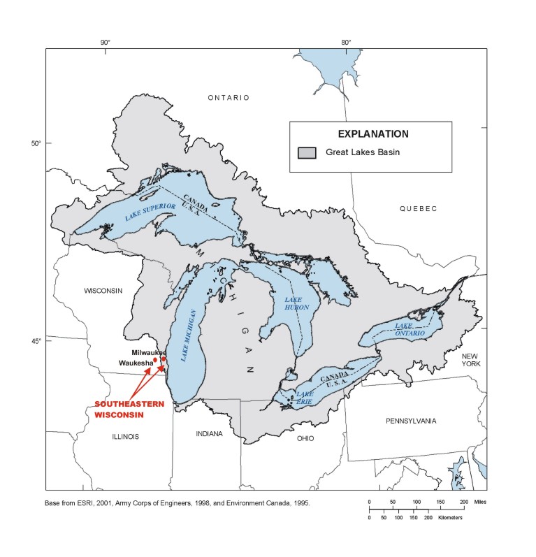
in and adjacent to the Lake Michigan Basin in southeastern Wisconsin. The case
study is interesting because the width of the Great Lakes surface-water basin
in the Waukesha-Milwaukee area is narrow. This map shows the topographically-defined
surface-water basin around the entire Great Lakes, that is the coastal strip
where precipitation falling on the surface flows into the Lakes and ultimately
the Atlantic Ocean via the St. Lawrence Seaway:
You can see that the strip is thin around Milwaukee,
in fact less than 10 miles wide. West of the divide, rainwater circulates to
rivers that empty into the Mississippi and, ultimately, the distant Gulf of Mexico
. For this reason, the watershed divide in southeastern Wisconsin is also called
a subcontinental divide.
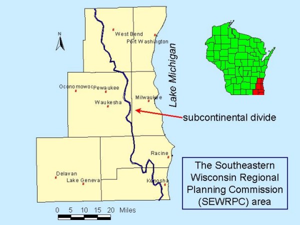
While the tributary area for surface water flowing to Lake Michigan is narrow
in southeastern Wisconsin, the tributary area for ground water could be much
larger. For example, it is possible that ground water under Waukesha, a city
that lies outside the Lake Michigan watershed basin, flows eastward toward the
Lake. This potential asymmetry between the size of the surface-water (i.e., watershed)
basin and the size of the ground-water basin raises difficulties when it comes
to managing the resource. The issue for policy makers is whether the waters of
the Great Lakes Basin correspond to all tributary waters including ground water,
or whether they are limited only to waters that stay on the surface within the
topographically-defined watershed basin. The question is made sharper and more
pressing by the increasing rates of ground-water pumping in many regions, including
the rapidly-growing area around Waukesha. Before these policy issues can be fully
resolved, it is important to understand how the ground-water-flow system operates,
how it is affected by pumping and how it is related to the surface-water network,
including the Great Lakes. The case study in southeastern Wisconsin provides
a context to think about these issues in a concrete setting.
This web site provides figures and charts to answer questions about the relation
of ground water to the Great Lakes. The evidence is derived from a ground-water
flow model recently constructed for southeastern Wisconsin by a team of hydrologists.
The study focuses on an area centered on Waukesha and covering seven counties,
four of which border Lake Michigan:
The model simplifies the real world and there are
many uncertainties associated with its inputs. Nevertheless, it is by far the
best instrument we have to understand the role of ground water in at least one
corner of the Great Lakes basin.
return to top |