USGS

Mercury Studies

USGS IN YOUR STATE

USGS Water Science Centers are located in each state.

There is a USGS Water Science Center office in each State. Washington Oregon California Idaho Nevada Montana Wyoming Utah Colorado Arizona New Mexico North Dakota South Dakota Nebraska Kansas Oklahoma Texas Minnesota Iowa Missouri Arkansas Louisiana Wisconsin Illinois Mississippi Michigan Indiana Ohio Kentucky Tennessee Alabama Pennsylvania West Virginia Georgia Florida Caribbean Alaska Hawaii New York Vermont New Hampshire Maine Massachusetts South Carolina North Carolina Rhode Island Virginia Connecticut New Jersey Maryland-Delaware-D.C.

ELA aerial viewUSGS Mercury Research Team

History and Mission

Around the mid 1980’s scientists across the globe began to reveal the occurrence of fish mercury levels - sufficient to prompt fish-consumption advisories - were from locations lacking substantive, on-site anthropogenic or geologic mercury sources. Soon after, it became clear a new mercury source was at play, one that could affect aquatic ecosystems anywhere on the planet: that source was atmospheric fallout. By the mid 1990’s, mercury was widely recognized as the most common contaminant of aquatic ecosystems worldwide, and exponentially increasing attention was being placed on the topic by scientists and resource management agencies. In 1995, the USGS initiated the Mercury Research Team (MRT) and assembled the Mercury Research Lab (MRL).

Science Support for Mercury Research

Mercury is global issue that is currently confronting resource managers and regulators in the US and globally.  As recently as ten years ago it would have been difficult to consider remediation strategies, but with a rapidly increasing scientific understanding possible solutions are now being discussed, The Mercury Research Team (MRT) in the USGS Wisconsin Water Science Center (WI WSC) office in Middleton, Wisconsin is national leader in mercury research and a major contributor in many areas of advancing scientific understanding. The MRT provides expert assistance to the USGS and other state and Federal agencies.  Assistance is provided through execution of studies, sample analysis for the Bureau and other federal and state agencies, methods development for field and lab procedures, interpreting data, and drafting reports.  We strive to provide the best possible data and service by remaining on the cutting edge of mercury research, and maintaining a state-of-the-art mercury analysis laboratory. 

  • Low-Level Speciation Analysis: As recently as 15 years ago, researchers could not reliably measure the mercury concentration of mercury in environmental samples due to the very low levels generally observed. In 1995 the USGS established the Mercury Research Lab (MRL), which serves as the analytical service point for the MRT, as well as the vast majority of the USGS generally. The MRL has a well-established, international reputation for excellence in the quantification and speciation of mercury in all forms of environmental samples (water, sediment, biota, and air).  We have developed and published methods prove out papers for most of our methods, but will always continue to strive to improve our capabilities.  As new approaches or ideas come forth and provide promise for improved speciation, sensitivity, or sample through put, the WMRL will seek to employ these procedures.

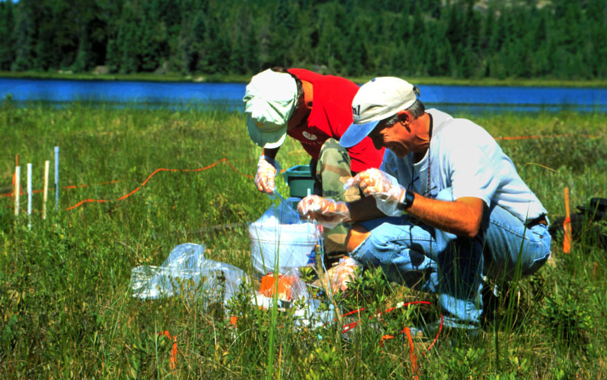
  • Scientific Leadership, Study Design and Execution:  The MRT is involved in studies from Alaska to Florida, and from California to Maine.  Our studies are always on the leading edge among researchers internationally, and often are done collaboratively with large research teams both within the USGS and outside the Bureau.  Often our projects are designed to provide an answer to land-resource management questions from DOI agencies or other state and federal agencies.  Last, MRT researchers continually provide scientific consultation and collaboration to USGS scientists, as well as those from other state and Federal agencies.


sampling in the ELA

Current Projects

The MRT is active on about 4-6 mercury-related research projects at point in time. Currently, we have two long-term projects and two recently started projects that are the emphasis of our research focus:

  • Mercury in Aquatic Ecosystems (supported by the Toxic Substances Hydrology Program)
  • Mercury in the Everglades Ecosystem (supported by the Priority Ecosystems Studies program)
  • Mercury Cycling and Bioaccumulation in the Great Lakes (supported by the Great Lakes Restoration Initiative)
  • The Carbon Farm
Mercury Research Lab

Mercury Research Lab

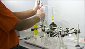
As recently as the 1990’s, reliably measurements of mercury in environmental samples were not readily available –especially species specific measurements. The MRL has a well-established, international reputation for excellence in the quantification and speciation of mercury in all forms of environmental samples (water, sediment, biota, and air). We have published methods prove out papers for most of our methods, but will always continue to strive to improve our capabilities. As new approaches or ideas come forth and provide promise for improved speciation, sensitivity, or sample through put, the WMRL will seek to employ these procedures.

Mobile Atmospheric Lab

Mobile Atmospheric Lab

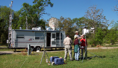
The MRT created the Mobile Atmospheric Mercury Laboratory (MALM in 2003. The facility is capable of making all the critical measurements that are relevant to atmospheric mercury studies, such as: speciate gas-phase mercury, ancillary gas-phase chemistry (e.g., NOx, SOx, ozone, aerosols, and carbon monoxide) and the full suite meteorological measurements to facility atmospheric mercury studies. The USGS has historically not been an active participant in atmospheric research, but the addition of this technical capacity makes the USGS one of the only agencies in the world that can study all aspects of the mercury contamination problem (atmosphere, hydrosphere, lithosphere, and biosphere).

Accessibility FOIA Privacy Policies and Notices

Take Pride in America logo USA.gov logo U.S. Department of the Interior | U.S. Geological Survey
URL: http://wi.water.usgs.gov/mercury/index.html
Page Contact Information: webmaster@wi.water.usgs.gov
Page Last Modified: Thursday, 10-Jan-2013 11:52:11 EST

05379500: Flow=1460cfs,Stage=8.35ft,Floodstage=9ft,2013-05-25 10:00,High,TREMPEALEAU RIVER AT DODGE, WI 05369500: Flow=39300cfs,Stage=12.68ft,Floodstage=13ft,2013-05-25 10:30,High,CHIPPEWA RIVER AT DURAND, WI 05360500: Flow=7510cfs,Stage=10.65ft,2013-05-25 10:00,High,FLAMBEAU RIVER NEAR BRUCE, WI 05356500: Flow=7110cfs,Stage=8.02ft,2013-05-25 10:00,High,CHIPPEWA RIVER NEAR BRUCE, WI 05356000: Flow=4460cfs,Stage=8.53ft,Floodstage=11ft,2013-05-25 08:00,High,CHIPPEWA RIVER AT BISHOPS BRIDGE NEAR WINTER, WI 04027500: Flow=1340cfs,Stage=3.15ft,2013-05-25 10:15,High,WHITE RIVER NEAR ASHLAND, WI 04027000: Flow=3680cfs,Stage=7.55ft,Floodstage=18ft,2013-05-25 11:45,High,BAD RIVER NEAR ODANAH, WI 05527800: Flow=0.13cfs,Stage=3.40ft,Floodstage=7ft,2013-05-25 10:30,Low,DES PLAINES RIVER AT RUSSELL, IL 05543830: Flow=279cfs,Stage=4.03ft,2013-05-25 10:15,>90,FOX RIVER AT WAUKESHA, WI 05437500: Flow=9390cfs,Stage=6.96ft,2013-05-25 10:30,>90,ROCK RIVER AT ROCKTON, IL 05430500: Flow=6480cfs,2013-05-25 12:00,Stage=8.35ft,2013-05-25 11:00:00,Floodstage=9ft,>90,ROCK RIVER AT AFTON, WI 05429500: Flow=414cfs,Stage=4.90ft,2013-05-25 10:30,>90,YAHARA RIVER AT MC FARLAND, WI 05426250: Flow=223cfs,Stage=2.82ft,Floodstage=3ft,2013-05-25 10:00,>90,BARK RIVER NEAR ROME, WI 05426000: Flow=1620cfs,Stage=4.78ft,2013-05-25 10:00,>90,CRAWFISH RIVER AT MILFORD, WI 05425500: Flow=2340cfs,Stage=4.16ft,Floodstage=5.5ft,2013-05-25 10:00,>90,ROCK RIVER AT WATERTOWN, WI 05423500: Flow=111cfs,Stage=2.92ft,Floodstage=6ft,2013-05-25 08:00,>90,SOUTH BRANCH ROCK RIVER AT WAUPUN, WI 05402000: Flow=1350cfs,Stage=8.64ft,Floodstage=12ft,2013-05-25 10:15,>90,YELLOW RIVER AT BABCOCK, WI 05396000: Flow=413cfs,Stage=3.53ft,Floodstage=10ft,2013-05-25 11:00,>90,BIG RIB RIVER AT RIB FALLS, WI 05382000: Flow=9260cfs,2013-05-25 10:00,Stage=9.91ft,2013-05-25 11:30:00,Floodstage=12ft,>90,BLACK RIVER NEAR GALESVILLE, WI 05378500: Flow=86500cfs,Stage=10.47ft,Floodstage=13ft,2013-05-25 11:45,>90,MISSISSIPPI RIVER AT WINONA, MN 05369000: Flow=2640cfs,Stage=8.20ft,2013-05-25 10:15,>90,RED CEDAR RIVER AT MENOMONIE, WI 05368000: Flow=591cfs,Stage=4.74ft,2013-05-25 08:00,>90,HAY RIVER AT WHEELER, WI 05365500: Flow=22800cfs,Stage=11.60ft,2013-05-25 10:00,>90,CHIPPEWA RIVER AT CHIPPEWA FALLS, WI 05362000: Flow=1740cfs,Stage=6.08ft,2013-05-25 08:15,>90,JUMP RIVER AT SHELDON, WI 05340500: Flow=12400cfs,Stage=7.03ft,2013-05-25 10:00,>90,ST. CROIX RIVER AT ST. CROIX FALLS, WI 05333500: Flow=3420cfs,Stage=3.55ft,Floodstage=7ft,2013-05-25 08:15,>90,ST. CROIX RIVER NEAR DANBURY, WI 04087030: Flow=81cfs,Stage=4.02ft,Floodstage=7.5ft,2013-05-25 11:30,>90,MENOMONEE RIVER AT MENOMONEE FALLS, WI 04087000: Flow=1670cfs,Stage=3.76ft,Floodstage=7ft,2013-05-25 10:00,>90,MILWAUKEE RIVER AT MILWAUKEE, WI 04086600: Flow=1590cfs,Stage=7.79ft,Floodstage=11ft,2013-05-25 10:05,>90,MILWAUKEE RIVER NEAR CEDARBURG, WI 04086500: Flow=263cfs,Stage=6.62ft,Floodstage=10ft,2013-05-25 10:30,>90,CEDAR CREEK NEAR CEDARBURG, WI 04086000: Flow=649cfs,Stage=3.25ft,Floodstage=8ft,2013-05-25 08:05,>90,SHEBOYGAN RIVER AT SHEBOYGAN, WI 04073500: Flow=2310cfs,Stage=11.57ft,Floodstage=13ft,2013-05-25 08:00,>90,FOX RIVER AT BERLIN, WI 04025500: Flow=491cfs,Stage=2.91ft,Floodstage=7ft,2013-05-25 08:15,>90,BOIS BRULE RIVER AT BRULE, WI 04024430: Flow=1210cfs,Stage=9.78ft,Floodstage=20ft,2013-05-25 08:00,>90,NEMADJI RIVER NEAR SOUTH SUPERIOR, WI 05434500: Flow=961cfs,Stage=6.82ft,Floodstage=13.5ft,2013-05-25 08:30,76-90,PECATONICA RIVER AT MARTINTOWN, WI 05430175: Flow=715cfs,Stage=5.28ft,Floodstage=10ft,2013-05-25 08:00,76-90,YAHARA RIVER NEAR FULTON, WI 05408000: Flow=269cfs,Stage=3.79ft,Floodstage=15ft,2013-05-25 10:00,76-90,KICKAPOO RIVER AT LA FARGE, WI 05404000: Flow=14900cfs,Stage=7.71ft,Floodstage=16ft,2013-05-25 11:30,76-90,WISCONSIN RIVER NEAR WISCONSIN DELLS, WI 05399500: Flow=299cfs,Stage=4.51ft,Floodstage=15.5ft,2013-05-25 11:00,76-90,BIG EAU PLEINE RIVER AT STRATFORD, WI 05398000: Flow=6030cfs,Stage=15.66ft,Floodstage=25ft,2013-05-25 12:00,76-90,WISCONSIN RIVER AT ROTHSCHILD, WI 05397500: Flow=389cfs,Stage=1.63ft,Floodstage=7ft,2013-05-25 11:00,76-90,EAU CLAIRE RIVER AT KELLY, WI 05393500: Flow=136cfs,Stage=2.52ft,2013-05-25 11:00,76-90,SPIRIT RIVER AT SPIRIT FALLS, WI 05389500: Flow=87900cfs,2013-05-25 11:30,Stage=13.15ft,2013-05-25 11:45:00,Floodstage=16ft,76-90,Mississippi River at McGregor, IA 05381000: Flow=1110cfs,2013-05-25 12:00,Stage=6.12ft,2013-05-25 09:45:00,Floodstage=18ft,76-90,BLACK RIVER AT NEILLSVILLE, WI 05370000: Flow=31cfs,Stage=12.57ft,2013-05-25 08:00,76-90,EAU GALLE RIVER AT SPRING VALLEY, WI 05344500: Flow=51900cfs,Stage=30.99ft,2013-05-25 11:15,76-90,MISSISSIPPI RIVER AT PRESCOTT, WI 04087240: Flow=222cfs,Stage=3.36ft,2013-05-25 10:00,76-90,ROOT RIVER AT RACINE, WI 04087120: Flow=191cfs,Stage=2.56ft,Floodstage=11ft,2013-05-25 11:55,76-90,MENOMONEE RIVER AT WAUWATOSA, WI 04087088: Flow=19cfs,2013-05-25 10:05,Stage=8.63ft,2013-05-25 12:00:00,76-90,UNDERWOOD CREEK AT WAUWATOSA, WI 04081000: Flow=298cfs,Stage=1.75ft,Floodstage=6ft,2013-05-25 08:15,76-90,WAUPACA RIVER NEAR WAUPACA, WI 04080000: Flow=683cfs,Stage=2.15ft,Floodstage=5ft,2013-05-25 11:00,76-90,LITTLE WOLF RIVER AT ROYALTON, WI 04074950: Flow=645cfs,2013-05-25 12:00,Stage=8.47ft,2013-05-25 08:00:00,Floodstage=11.5ft,76-90,WOLF RIVER AT LANGLADE, WI 04069500: Flow=1450cfs,Stage=3.38ft,Floodstage=10ft,2013-05-25 08:15,76-90,PESHTIGO RIVER AT PESHTIGO, WI 04067500: Flow=5710cfs,2013-05-25 12:00,Stage=11.56ft,2013-05-25 10:05:00,Floodstage=15ft,76-90,MENOMINEE RIVER NEAR MC ALLISTER, WI 04066800: Flow=5580cfs,Stage=11.77ft,Floodstage=17ft,2013-05-25 08:30,76-90,MENOMINEE RIVER AT KOSS, MI 04063500: Flow=3100cfs,Stage=8.19ft,Floodstage=12ft,2013-05-25 10:30,76-90,MENOMINEE RIVER AT TWIN FALLS NEAR IRON MT, MI 04031000: Flow=774cfs,Stage=3.43ft,Floodstage=10ft,2013-05-25 11:00,76-90,BLACK RIVER NEAR BESSEMER, MI 05548280: Flow=113cfs,Stage=4.26ft,2013-05-25 11:00,25-75,NIPPERSINK CREEK NEAR SPRING GROVE, IL 05544200: Flow=49cfs,Stage=2.44ft,Floodstage=5ft,2013-05-25 08:30,25-75,MUKWONAGO RIVER AT MUKWONAGO, WI 05433000: Flow=182cfs,Stage=5.01ft,Floodstage=11ft,2013-05-25 08:00,25-75,EAST BRANCH PECATONICA RIVER NR BLANCHARDVILLE, WI 05431486: Flow=142cfs,Stage=3.95ft,Floodstage=8ft,2013-05-25 08:00,25-75,TURTLE CREEK AT CARVERS ROCK ROAD NEAR CLINTON, WI 05430150: Flow=122cfs,Stage=4.93ft,2013-05-25 08:00,25-75,BADFISH CREEK NEAR COOKSVILLE, WI 05427965: Flow=0.25cfs,Stage=0.44ft,2013-05-25 11:00,25-75,SPRING HARBOR STORM SEWER AT MADISON, WI 05427948: Flow=3.3cfs,Stage=3.45ft,2013-05-25 10:00,25-75,PHEASANT BRANCH AT MIDDLETON, WI 05414820: Flow=28cfs,Stage=4.77ft,2013-05-25 10:15,25-75,SINSINAWA RIVER NEAR MENOMINEE, IL 05413500: Flow=182cfs,Stage=5.38ft,Floodstage=18ft,2013-05-25 10:00,25-75,GRANT RIVER AT BURTON, WI 05407000: Flow=12300cfs,Stage=3.40ft,Floodstage=9ft,2013-05-25 10:00,25-75,WISCONSIN RIVER AT MUSCODA, WI 05406500: Flow=47cfs,Stage=1.91ft,Floodstage=7ft,2013-05-25 12:00,25-75,BLACK EARTH CREEK AT BLACK EARTH, WI 05405000: Flow=441cfs,Stage=8.58ft,Floodstage=16ft,2013-05-25 10:00,25-75,BARABOO RIVER NEAR BARABOO, WI 05401050: Flow=92cfs,Stage=5.20ft,2013-05-25 08:45,25-75,TENMILE CREEK NEAR NEKOOSA, WI 05395000: Flow=3930cfs,2013-05-25 12:00,Stage=6.06ft,2013-05-25 11:00:00,Floodstage=11ft,25-75,WISCONSIN RIVER AT MERRILL, WI 05394500: Flow=200cfs,Stage=2.68ft,Floodstage=7ft,2013-05-25 12:00,25-75,PRAIRIE RIVER NEAR MERRILL, WI 05391000: Flow=799cfs,Stage=2.39ft,2013-05-25 11:00,25-75,WISCONSIN RIVER @ RAINBOW LAKE NR LAKE TOMAHAWK,WI 04087257: Flow=23cfs,Stage=1.87ft,2013-05-25 10:00,25-75,PIKE RIVER NEAR RACINE, WI 04087233: Flow=12cfs,Stage=2.56ft,Floodstage=9ft,2013-05-25 10:15,25-75,ROOT RIVER CANAL NEAR FRANKLIN, WI 04087220: Flow=23cfs,Stage=3.01ft,Floodstage=8ft,2013-05-25 10:15,25-75,ROOT RIVER NEAR FRANKLIN, WI 04087204: Flow=20cfs,Stage=2.64ft,Floodstage=8ft,2013-05-25 10:10,25-75,OAK CREEK AT SOUTH MILWAUKEE, WI 04085427: Flow=448cfs,Stage=5.56ft,Floodstage=10ft,2013-05-25 11:30,25-75,MANITOWOC RIVER AT MANITOWOC, WI 04085200: Flow=46cfs,Stage=9.17ft,Floodstage=14ft,2013-05-25 11:00,25-75,KEWAUNEE RIVER NEAR KEWAUNEE, WI 04071000: Flow=647cfs,Stage=1.83ft,Floodstage=7.5ft,2013-05-25 10:00,25-75,OCONTO RIVER NEAR GILLETT, WI 04066500: Flow=308cfs,Stage=3.55ft,2013-05-25 08:00,25-75,PIKE RIVER AT AMBERG, WI 04064500: Flow=675cfs,Stage=3.46ft,Floodstage=7ft,2013-05-25 10:00,25-75,PINE RIVER BELOW PINE R POWERPLANT NR FLORENCE, WI 04063700: Flow=162cfs,Stage=2.98ft,Floodstage=6ft,2013-05-25 10:00,25-75,POPPLE RIVER NEAR FENCE, WI 04063000: Flow=2990cfs,Stage=5.51ft,Floodstage=9ft,2013-05-25 10:00,25-75,MENOMINEE RIVER NEAR FLORENCE, WI 04062000: Flow=221cfs,Stage=3.99ft,2013-05-25 10:30,25-75,PAINT RIVER NEAR ALPHA, MI 04060993: Flow=358cfs,Stage=3.86ft,2013-05-25 10:30,25-75,BRULE RIVER AT US HIGHWAY 2 NEAR FLORENCE, WI 04060500: Flow=90cfs,Stage=4.65ft,Floodstage=11ft,2013-05-25 10:30,25-75,IRON RIVER AT CASPIAN, MI 04037500: Flow=46cfs,Stage=4.69ft,2013-05-25 10:00,25-75,CISCO BRANCH ONTONAGON R AT CISCO LAKE OUTLET, MI 464646092052900: Stage=601.10ft,2013-05-25 08:00:00,Not ranked,Rating being developed or revised,SUPERIOR BAY DULUTH SHIP CANAL AT DULUTH, MN 450456092225801: Flow=0.000000cfs,Stage=-0.012ft,2013-05-25 10:00,Not ranked,DISCOVERY FARMS-WILLOW WATERWAY 1 NEAR CYLON, WI 450115092180101: Flow=0.000000cfs,Stage=-0.003ft,2013-05-25 10:00,Not ranked,DISCOVERY FARMS-WILLOW WATERWAY 2 NR WOODVILLE, WI 441624088045601: Flow=0.000000cfs,Stage=-0.004ft,2013-05-25 12:00,Not ranked,GLRI EAST RIVER WATERWAY NUMBER 1 NR GREENLEAF, WI 441546088082001: Flow=0.000000cfs,Stage=-0.023ft,2013-05-25 12:00,Not ranked,GLRI EAST RIVER WATERWAY NUMBER 2 NR GREENLEAF, WI 434425090462401: Flow=0.014320cfs,Stage=0.045ft,2013-05-25 10:00,Not ranked,DISCOVERY FARMS-JERSEY WATERWAY 6 AT CASHTON, WI 434311090461401: Flow=0.000900cfs,Stage=0.010ft,2013-05-25 10:00,Not ranked,DISCOVERY FARMS-JERSEY WATERWAY 4 NEAR CASHTON, WI 434250090461401: Flow=0.000000cfs,Stage=-0.006ft,2013-05-25 10:00,Not ranked,DISCOVERY FARMS-JERSEY WATERWAY 5 NEAR CASHTON, WI 434246090465801: Flow=0.000000cfs,Stage=-0.003ft,2013-05-25 10:15,Not ranked,DISCOVERY FARMS-JERSEY WATERWAY 3 NEAR CASHTON, WI 434244090470801: Flow=0.000000cfs,Stage=-0.001ft,2013-05-25 10:00,Not ranked,DISCOVERY FARMS-JERSEY WATERWAY 2 NEAR CASHTON, WI 434209090491101: Flow=0.000000cfs,Stage=-0.010ft,2013-05-25 10:00,Not ranked,DISCOVERY FARMS-JERSEY WATERWAY 1 NEAR CASHTON, WI 434034088252401: Flow=0.008620cfs,Stage=0.014ft,2013-05-20 10:00,Not ranked,SCF W BR MILWAUKEE RIVER WATERWAY 1 NEAR BYRON, WI 433727088215801: Flow=0.000000cfs,Stage=-0.003ft,2013-05-25 10:00,Not ranked,SCF W BR MILWAUKEE RIVER WATERWAY 2 NR ASHFORD, WI 433615088202501: Flow=0.000000cfs,Stage=-0.002ft,2013-05-25 10:00,Not ranked,SCF W BR MILWAUKEE RIVER WATERWAY 3 NR ASHFORD, WI 431250089282901: Flow=0.002400cfs,Stage=0.020ft,2013-05-25 10:00,Not ranked,DANE COUNTY MRBI WATERWAY NUMBER 1 NR WAUNAKEE, WI 431212089314801: Stage=0.034ft,2013-05-25 10:00,Not ranked,DANE CO MRBI WATERWAY 2 NR SPRINGFIELD CORNERS, WI 431208089314901: Stage=0.061ft,2013-05-25 10:00,Not ranked,DANE CO. MRBI TILE #1 NEAR SPRINGFIELD CORNERS, WI 430532089315602: Stage=0.034ft,2013-05-25 12:00,Not ranked,BIO CELL SS-OUTLET-AT USGS OFFICE AT MIDDLETON, WI 430532089315601: Stage=-0.058ft,2013-05-25 12:00,Not ranked,BIO CELL SS-INLET-AT USGS OFFICE AT MIDDLETON, WI 430402089282000: Stage=0.03ft,2013-05-25 12:00,Not ranked,SOUTH KENOSHA DRIVE STORM SEWER AT MADISON, WI 430402089183501: Stage=-0.05ft,2013-05-25 12:02,Not ranked,US HWY 51 WISDOT GRASS SWALES DOWNSTRM MADISON, WI 430358089281901: Stage=0.12ft,2013-05-25 12:00,Not ranked,SOUTH KENOSHA DRIVE (EAST) STORM SEWR @ MADISON,WI 430356089183502: Stage=0.01ft,2013-05-25 12:00,Not ranked,US HWY 51 WISDOT GRASS SWALES MIDDLE MADISON, WI 425715089164700: Stage=3.48ft,2013-05-25 10:15,Not ranked,LAKE KEGONSA AT BARBER DRIVE NEAR STOUGHTON, WI 424848088083100: Stage=8.20ft,2013-05-25 11:15,Not ranked,WIND LAKE AT OUTLET AT WIND LAKE, WI 423525088260400: Stage=2.44ft,2013-05-25 08:20,Not ranked,GENEVA LAKE AT LAKE GENEVA, WI 055451345: Flow=40cfs,Stage=8.69ft,2013-05-25 08:20,Not ranked,WHITE RIVER AT CENTER STREET AT LAKE GENEVA, WI 054279465: Flow=0.69cfs,Stage=2.20ft,2013-05-25 10:00,Not ranked,S FORK PHEASANT BRANCH @ DEMING WAY @ MIDDLETON,WI 054041665: Flow=441cfs,Stage=7.75ft,Floodstage=14ft,2013-05-25 11:30,Not ranked,BARABOO RIVER AT MAIN STREET AT REEDSBURG, WI 053813595: Flow=5160cfs,2013-05-25 12:00,Stage=42.49ft,2013-05-25 10:00:00,Floodstage=47ft,Not ranked,BLACK RIVER DS ST HWY 54 AT BLACK RIVER FALLS, WI 053674967: Flow=13cfs,Stage=4.09ft,2013-05-25 11:15,Not ranked,Trout Creek at Tenth St. near Bloomer, WI 053674962: Flow=2.6cfs,Stage=1.89ft,2013-05-25 11:45,Not ranked,TROUT CREEK AT CNTY TRUNK HIGHWAY DD NR BLOOMER,WI 053416972: Flow=90cfs,Stage=4.22ft,2013-05-25 10:00,Not ranked,WILLOW RIVER @ COUNTY TRUNK HIGHWAY T AT JEWETT,WI 053416966: Flow=0.54cfs,Stage=2.88ft,2013-05-25 10:00,Not ranked,DRY RUN AT 190TH STREET NEAR JEWETT, WI 040871488: Flow=52cfs,Stage=12.50ft,2013-05-23 08:55,Not ranked,WILSON PARK CR @ ST. LUKES HOSPTL @ MILWAUKEE, WI 040871476: Flow=0.00cfs,Stage=0.10ft,2013-05-25 11:00,Not ranked,HOLMES AVE CR TRB @ GMIA OUTFALL #1 @ MILWAUKEE,WI 040871475: Flow=0.70cfs,2013-05-25 11:55,Stage=10.85ft,2013-05-25 10:55:00,Not ranked,WILSON PARK CREEK @ GMIA OUTFALL #7 @ MILWAUKEE,WI 040871473: Flow=0.52cfs,Stage=10.70ft,2013-05-25 11:50,Not ranked,WILSON PARK CREEK AT GMIA INFALL AT MILWAUKEE, WI 040869416: Flow=7.8cfs,Stage=3.83ft,2013-05-25 11:00,Not ranked,LINCOLN CREEK @ SHERMAN BOULEVARD AT MILWAUKEE, WI 040857005: Flow=9.2cfs,Stage=4.55ft,2013-05-25 12:00,Not ranked,OTTER CREEK AT WILLOW ROAD NEAR PLYMOUTH, WI 040854592: Flow=7.5cfs,Stage=4.00ft,2013-05-25 10:00,Not ranked,FISHER CREEK AT HOWARDS GROVE, WI 040851385: Flow=10500cfs,Stage=577.58ft,Floodstage=584ft,2013-05-25 11:00,Not ranked,FOX RIVER AT OIL TANK DEPOT AT GREEN BAY, WI 040851325: Flow=3.3cfs,Stage=2.01ft,2013-05-25 10:15,Not ranked,BAIRD CREEK AT SUPERIOR ROAD AT GREEN BAY, WI 040734605: Stage=6.59ft,2013-05-25 10:00,Not ranked,GREEN LAKE SW INLET @ CT HIGHWY K NR GREEN LAKE,WI 040263205: Flow=22cfs,Stage=1.51ft,Floodstage=5ft,2013-05-25 11:05,Not ranked,WHITTLESEY CREEK NEAR ASHLAND, WI 05548170: Flow=43cfs,Stage=2.33ft,2013-05-25 11:45,Not ranked,NORTH BRANCH NIPPERSINK CREEK AT GENOA CITY, WI 05548000: Stage=4.18ft,2013-05-25 10:45,Not ranked,NIPPERSINK LAKE AT FOX LAKE, IL 05547500: Stage=4.21ft,2013-05-25 10:30,Not ranked,FOX LAKE NEAR LAKE VILLA, IL 05547000: Stage=4.26ft,2013-05-25 10:45,Not ranked,CHANNEL LAKE NEAR ANTIOCH, IL 05545750: Flow=895cfs,Stage=7.89ft,Floodstage=10ft,2013-05-25 11:00,Not ranked,FOX RIVER NEAR NEW MUNSTER, WI 05544475: Stage=4.60ft,Floodstage=7.5ft,2013-05-25 11:15,Not ranked,FOX RIVER AT ROCHESTER, WI 05544385: Stage=12.05ft,2013-05-25 11:45,Not ranked,MUSKEGO (BIG MUSKEGO) LAKE OUTLET NR WIND LAKE, WI 05527950: Flow=23cfs,Stage=6.80ft,2013-05-25 10:30,Not ranked,MILL CREEK AT OLD MILL CREEK, IL 05527910: Flow=7.8cfs,Stage=17.11ft,2013-05-25 10:45,Not ranked,NORTH MILL CREEK NEAR MILBURN, IL 05527905: Flow=2.4cfs,Stage=11.34ft,2013-05-25 10:30,Not ranked,HASTINGS CREEK NEAR LINDENHURST, IL 05527900: Flow=14cfs,Stage=7.97ft,2013-05-25 10:30,Not ranked,NORTH MILL CREEK AT HICKORY CORNERS, IL 05438283: Flow=9.7cfs,Stage=4.98ft,2013-05-25 08:00,Not ranked,PISCASAW CREEK NEAR WALWORTH, WI 05437050: Flow=2500cfs,Stage=7.29ft,Floodstage=12ft,2013-05-25 10:45,Not ranked,PECATONICA RIVER NR SHIRLAND, ILL 05436500: Flow=540cfs,Stage=1.87ft,Floodstage=5ft,2013-05-24 14:00,Not ranked,SUGAR RIVER NEAR BRODHEAD, WI 05435950: Flow=60cfs,Stage=3.25ft,2013-05-25 10:00,Not ranked,SUGAR RIVER NEAR VERONA, WI 05435943: Flow=14cfs,Stage=4.38ft,2013-05-25 08:00,Not ranked,BADGER MILL CREEK AT VERONA, WI 05432927: Flow=21cfs,Stage=9.53ft,2013-05-25 10:00,Not ranked,PLEASANT VALLEY CREEK @ CTH H NR BLANCHARDVILLE,WI 05432695: Flow=14cfs,Stage=7.61ft,2013-05-25 10:00,Not ranked,RIDGEWAY BRANCH NEAR HOLLANDALE, WI 05432500: Stage=3.12ft,Floodstage=13.5ft,2013-05-25 10:00,Not ranked,PECATONICA RIVER AT DARLINGTON, WI 05431016: Flow=8.2cfs,Stage=8.55ft,2013-05-25 10:00,Not ranked,JACKSON CREEK AT MOUND ROAD NEAR ELKHORN, WI 05429700: Flow=529cfs,Stage=6.45ft,2013-05-25 10:30,Not ranked,YAHARA RIVER @ FORTON STREET BRIDGE @ STOUGHTON,WI 05429510: Flow=358cfs,2013-05-25 10:30,Stage=5.76ft,2013-01-28 08:10:00,Not ranked,YAHARA RIVER @ EXCHANGE ST. BRIDGE @ MC FARLAND,WI 05429485: Stage=4.97ft,2013-05-25 10:30,Not ranked,LAKE WAUBESA AT MC FARLAND, WI 05429000: Stage=5.33ft,2013-05-25 10:00,Not ranked,LAKE MONONA AT MADISON, WI 05428500: Flow=224cfs,Stage=5.53ft,2013-05-25 10:25,Not ranked,YAHARA RIVER AT EAST MAIN STREET AT MADISON, WI 05428000: Stage=10.18ft,2013-05-25 10:30,Not ranked,LAKE MENDOTA AT MADISON, WI 05427943: Flow=0.68cfs,Stage=3.14ft,2013-05-25 12:00,Not ranked,PHEASANT BRANCH AT AIRPORT ROAD NEAR MIDDLETON, WI 05427930: Flow=2.6cfs,Stage=10.42ft,2013-05-24 18:55,Not ranked,DORN (SPRING) CREEK AT CT HIGHWAY M NR WAUNAKEE,WI 05427927: Flow=5.3cfs,Stage=2.14ft,2013-05-25 11:00,Not ranked,DORN (SPRING) CREEK @ CT HIGHWAY Q NR WAUNAKEE, WI 05427910: Flow=18cfs,Stage=10.23ft,2013-05-25 11:00,Not ranked,SIXMILE CREEK @ COUNTY TRNK HGHWY M NR WAUNAKEE,WI 05427880: Flow=13cfs,Stage=2.03ft,2013-05-24 18:45,Not ranked,SIXMILE CREEK AT STATE HIGHWAY 19 NEAR WAUNAKEE,WI 05427850: Flow=115cfs,Stage=10.29ft,2013-05-25 11:30,Not ranked,YAHARA RIVER AT STATE HIGHWAY 113 AT MADISON, WI 05427718: Flow=31cfs,Stage=1.21ft,2013-05-25 10:00,Not ranked,YAHARA RIVER AT WINDSOR, WI 05427530: Flow=4960cfs,Stage=5.48ft,2013-05-25 11:00,Not ranked,ROCK RIVER AT NEWVILLE, WI 05427235: Stage=9.26ft,Floodstage=10ft,2013-05-25 10:00,Not ranked,LAKE KOSHKONONG NEAR NEWVILLE, WI 05427085: Flow=4550cfs,Stage=14.72ft,Floodstage=6ft,2013-05-25 11:00,Not ranked,ROCK RIVER AT ROBERT STREET AT FORT ATKINSON, WI 05426380: Stage=0.96ft,2013-05-25 11:30,Not ranked,Paradise Springs Creek near Eagle, WI 05426350: Stage=0.39ft,2013-05-25 11:15,Not ranked,Scuppernong R upstream from marl pit near Eagle,WI 05426067: Flow=82cfs,Stage=13.15ft,2013-05-25 10:15,Not ranked,BARK RIVER AT NAGAWICKA ROAD AT DELAFIELD, WI 05426060: Flow=68cfs,Stage=3.68ft,2013-05-25 12:00,Not ranked,BARK RIVER AT COUNTY TRUNK HIGHWAY K NR MERTON, WI 05425912: Flow=314cfs,Stage=841.14ft,Floodstage=843.5ft,2013-05-25 10:00,Not ranked,BEAVERDAM RIVER AT BEAVER DAM, WI 05424057: Flow=1280cfs,Stage=6.93ft,Floodstage=8.5ft,2013-05-25 12:00,Not ranked,ROCK RIVER AT HORICON, WI 05414000: Stage=3.62ft,Floodstage=9ft,2013-05-25 10:00,Not ranked,PLATTE RIVER NEAR ROCKVILLE, WI 05411500: Stage=15.50ft,2013-05-25 11:45,Not ranked,Mississippi River at Clayton, IA 05410490: Flow=993cfs,Stage=8.78ft,Floodstage=12ft,2013-05-25 11:30,Not ranked,KICKAPOO RIVER AT STEUBEN, WI 05408480: Flow=4.3cfs,Stage=2.79ft,2013-05-25 10:00,Not ranked,W FORK KICKAPOO R @ PEACEFUL VAL RD NR CASHTON, WI 05408476: Flow=0.00cfs,Stage=0.00ft,2013-05-25 10:00,Not ranked,WEST FORK KICKAPOO RIVER @ OGDEN AVE AT CASHTON,WI 05407470: Flow=106cfs,Stage=8.77ft,Floodstage=16ft,2013-05-25 08:30,Not ranked,KICKAPOO RIVER AT STATE HIGHWAY 33 AT ONTARIO, WI 05406457: Flow=11cfs,Stage=1.93ft,2013-05-25 12:00,Not ranked,BLACK EARTH CREEK NR BREWERY RD @ CROSS PLAINS, WI 05404500: Stage=9.07ft,2013-05-25 08:00,Not ranked,DEVILS LAKE NEAR BARABOO, WI 05403500: Flow=624cfs,Stage=5.61ft,2013-05-20 18:00,Not ranked,LEMONWEIR RIVER AT NEW LISBON, WI 05403000: Flow=1820cfs,Stage=13.45ft,2013-05-25 12:00,Not ranked,YELLOW RIVER AT NECEDAH, WI 05401556: Flow=153cfs,2013-05-25 11:30,Not ranked,BIG ROCHE A CRI CREEK @ STATE HWY 21 NR ARKDALE,WI 05400718: Flow=916cfs,Stage=5.37ft,2013-05-25 11:30,Not ranked,MILL CREEK @ COUNTY TRUNK HIGHWAY PP NR PLOVER, WI 05400513: Flow=285cfs,Stage=3.57ft,2013-05-25 11:30,Not ranked,PLOVER RIVER AT HIGHWAY 66 AT STEVENS POINT, WI 05400220: Flow=638cfs,Stage=8.15ft,2013-05-25 11:30,Not ranked,LITTLE EAU PLEINE RIVER NEAR ROZELLVILLE, WI 05399580: Flow=27cfs,Stage=3.74ft,2013-05-25 11:45,Not ranked,FREEMAN CREEK AT HALDER, WI 05399550: Flow=142cfs,Stage=7.42ft,2013-05-25 10:00,Not ranked,FENWOOD CREEK AT BRADLEY, WI 05395063: Flow=109cfs,Stage=4.38ft,2013-05-25 11:30,Not ranked,PINE RIVER AT CENTER AVENUE NEAR MERRILL, WI 05390500: Stage=90.24ft,2013-05-25 11:30,Not ranked,ANVIL LAKE NEAR EAGLE RIVER, WI 05390100: Stage=80.59ft,Floodstage=82ft,2013-05-25 10:00,Not ranked,LAC VIEUX DESERT NEAR LAND O\'LAKES, WI 05389400: Flow=26cfs,Stage=4.36ft,2013-05-25 11:00,Not ranked,Bloody Run Creek near Marquette, IA 05389000: Flow=554cfs,Stage=6.36ft,2013-05-25 11:45,Not ranked,Yellow River near Ion, IA 05388410: Stage=20.70ft,Floodstage=625ft,2013-05-25 11:30,Not ranked,Mississippi Riv at Lock and Dam 9 nr Lynxville, WI 05386400: Stage=32.15ft,2013-05-25 11:45,Not ranked,MISSISSIPPI RIVER AT BROWNSVILLE, MN 05383075: Flow=992cfs,2013-05-25 12:00,Stage=5.75ft,2013-05-25 08:00:00,Not ranked,LA CROSSE RIVER NEAR LA CROSSE, WI 05382325: Flow=351cfs,Stage=4.28ft,2013-05-25 08:00,Not ranked,LA CROSSE RIVER AT SPARTA, WI 05382284: Flow=72cfs,Stage=6.00ft,2013-05-25 08:05,Not ranked,SILVER CREEK AT STATE HIGHWAY 21 NEAR ANGELO, WI 05382267: Flow=163cfs,Stage=7.40ft,2013-05-25 08:00,Not ranked,LA CROSSE RIVER @ CNTY TRUNK HIGHWY BB NR TOMAH,WI 05382257: Flow=24cfs,Stage=3.21ft,2013-05-25 08:05,Not ranked,STILLWELL CREEK AT YARD ROAD NEAR TOMAH, WI 05382255: Flow=2.5cfs,Stage=2.55ft,2013-05-25 08:00,Not ranked,STILLWELL CREEK AT 16TH COURT NEAR TOMAH, WI 05378490: Stage=11.68ft,2013-05-25 11:00,Not ranked,MISSISSIPPI RIVER AT LOCK AND DAM 5A NR WINONA, MN 05365550: Flow=26200cfs,Stage=14.56ft,2013-05-25 11:30,Not ranked,Chippewa River at Eau Claire below Dells Dam 05364422: Flow=2.5cfs,Stage=2.25ft,2013-05-25 11:45,Not ranked,COMO CREEK TRIBUTARY NEAR BLOOMER, WI 05357335: Flow=149cfs,Stage=4.36ft,2013-05-25 11:15,Not ranked,BEAR RIVER NEAR MANITOWISH WATERS, WI 05357302: Flow=43cfs,2013-05-25 12:00,Not ranked,MANITOWISH RIVER AT ST HWY 51 NR MANITOWISH WATERS 05357245: Flow=63cfs,Stage=1.57ft,2013-05-25 06:15,Not ranked,TROUT RIVER AT TROUT LAKE NEAR BOULDER JUNCTION,WI 05357230: Flow=1.9cfs,Stage=7.68ft,2013-05-25 06:30,Not ranked,NORTH CREEK AT TROUT LAKE NEAR BOULDER JUNCTION,WI 05357225: Flow=4.2cfs,Stage=7.92ft,2013-05-25 06:15,Not ranked,STEVENSON CREEK @ CT HWY M NR BOULDER JUNCTION, WI 05357215: Flow=12cfs,Stage=1.51ft,2013-05-25 06:15,Not ranked,ALLEQUASH CREEK @ CT HWY M NR BOULDER JUNCTION, WI 05357206: Flow=3.6cfs,Stage=0.48ft,2013-05-25 11:15,Not ranked,ALLEQUASH CREEK SITE NO. 3 NR BOULDER JUNCTION, WI 05344490: Flow=9920cfs,Stage=31.04ft,2013-05-25 11:15,Not ranked,ST. CROIX RIVER AT PRESCOTT, WI 05342000: Flow=165cfs,Stage=10.77ft,2013-05-25 10:05,Not ranked,KINNICKINNIC RIVER NEAR RIVER FALLS, WI 05341752: Flow=232cfs,Stage=4.16ft,2013-05-25 10:05,Not ranked,WILLOW RIVER @ WILLOW R STATE PARK NR BURKHARDT,WI 05341694: Flow=16cfs,Stage=4.58ft,2013-05-25 10:00,Not ranked,SOUTH FORK WILLOW RIVER AT US HWY 63 NEAR CYLON,WI 05341687: Flow=50cfs,Stage=5.30ft,2013-05-25 10:00,Not ranked,WILLOW RIVER AT STATE HIGHWAY 46 NEAR DEER PARK,WI 05331833: Flow=497cfs,Stage=3.08ft,2013-05-25 08:30,Not ranked,NAMEKAGON RIVER AT LEONARDS, WI 04087214: Flow=11cfs,Stage=10.82ft,2013-05-25 11:00,Not ranked,ROOT RIVER AT GRANGE AVENUE AT GREENFIELD, WI 04087170: Stage=7.01ft,2013-05-25 10:05,Not ranked,MILWAUKEE RIVER AT MOUTH AT MILWAUKEE, WI 04087159: Flow=8.4cfs,Stage=6.22ft,Floodstage=16ft,2013-05-25 11:30,Not ranked,KINNICKINNIC RIVER @ S. 11TH STREET @ MILWAUKEE,WI 04087142: Flow=149cfs,Stage=11.59ft,2013-05-25 11:30,Not ranked,MENOMONEE RIVER AT 16TH STREET AT MILWAUKEE, WI 04087119: Flow=3.6cfs,Stage=6.02ft,2013-05-25 10:45,Not ranked,HONEY CREEK AT WAUWATOSA, WI 04087070: Flow=36cfs,2013-05-25 12:00,Stage=5.13ft,2013-05-25 10:00:00,Not ranked,LITTLE MENOMONEE RIVER AT MILWAUKEE, WI 04087050: Flow=9.4cfs,Stage=2.31ft,2013-05-25 11:25,Not ranked,LITTLE MENOMONEE RIVER NEAR FREISTADT, WI 04086139: Stage=3.84ft,2013-05-25 10:00:00,Not ranked,Rating being developed or revised,WEST BRANCH MILWAUKEE RIVER NEAR KEWASKUM, WI 04086120: Stage=3.41ft,2013-05-25 10:00:00,Not ranked,Rating being developed or revised,WEST BRANCH MILWAUKEE RIVER @ CTH K NEAR LOMIRA,WI 04086110: Stage=2.46ft,2013-05-25 10:00,Not ranked,WEST BRANCH MILWAUKEE RIVER AT CTH F NEAR BYRON,WI 04085108: Flow=16cfs,Stage=5.21ft,2013-05-25 10:00,Not ranked,EAST RIVER @ CNTY TRUNK HIGHWAY ZZ NR GREENLEAF,WI 04084911: Flow=4.5cfs,Stage=2.49ft,2013-05-25 12:00,Not ranked,PLUM CREEK NEAR WRIGHTSTOWN, WI 04084445: Flow=5879cfs,Stage=6.07ft,Floodstage=8.4ft,2013-05-25 12:00,Not ranked,FOX RIVER AT APPLETON, WI 04084255: Stage=2.93ft,2013-05-25 08:45,Not ranked,LAKE WINNEBAGO NEAR STOCKBRIDGE, WI 04084038: Stage=748.94ft,2013-05-25 11:05,Not ranked,DE NEVEU CREEK @ E. MERRILL ST. AT FOND DU LAC, WI 04082500: Stage=3.07ft,Floodstage=3.5ft,2013-05-25 08:30,Not ranked,LAKE WINNEBAGO AT OSHKOSH, WI 04082400: Flow=5080cfs,Stage=6.31ft,Floodstage=7.5ft,2013-05-25 12:00,Not ranked,FOX RIVER AT OSHKOSH, WI 04079000: Flow=2670cfs,Stage=5.08ft,Floodstage=9ft,2013-05-25 02:00,Not ranked,WOLF RIVER AT NEW LONDON, WI 04078500: Flow=725cfs,Stage=4.22ft,Floodstage=7ft,2013-05-24 08:30,Not ranked,EMBARRASS RIVER NEAR EMBARRASS, WI 04077630: Flow=174cfs,Stage=6.25ft,2013-05-25 11:30,Not ranked,RED RIVER AT MORGAN ROAD NEAR MORGAN, WI 04073466: Flow=65cfs,Stage=6.92ft,2013-05-25 10:05,Not ranked,SILVER CREEK AT SPAULDING ROAD NEAR GREEN LAKE, WI 04073458: Flow=2.4cfs,Stage=4.76ft,2013-05-25 10:00,Not ranked,ROY CREEK AT ROY CREEK ROAD NEAR GREEN LAKE, WI 04073365: Flow=1640cfs,Stage=7.30ft,Floodstage=9.5ft,2013-05-25 09:00,Not ranked,FOX RIVER AT PRINCETON, WI 04072150: Flow=59cfs,Stage=12.01ft,Floodstage=18ft,2013-05-25 08:00,Not ranked,DUCK CREEK NEAR HOWARD, WI 04071765: Flow=839cfs,Stage=5.26ft,Floodstage=9ft,2013-05-25 10:00,Not ranked,OCONTO RIVER NEAR OCONTO, WI 04069416: Flow=1310cfs,Stage=9.13ft,Floodstage=12ft,2013-05-25 08:40,Not ranked,PESHTIGO RIVER AT PORTERFIELD, WI 04067958: Flow=599cfs,Stage=4.76ft,2013-05-25 08:45,Not ranked,PESHTIGO RIVER NEAR WABENO, WI 04066030: Flow=4490cfs,Stage=8.64ft,Floodstage=14ft,2013-05-25 10:15,Not ranked,MENOMINEE RIVER AT WHITE RAPIDS DAM NEAR BANAT, MI 04066003: Flow=4790cfs,Stage=9.48ft,Floodstage=14ft,2013-05-25 10:00,Not ranked,MENOMINEE RIVER BELOW PEMENE CREEK NR PEMBINE, WI 04065106: Flow=3740cfs,Stage=8.03ft,Floodstage=13ft,2013-05-25 11:00,Not ranked,MENOMINEE RIVER AT NIAGARA, WI 04062011: Flow=780cfs,Stage=7.26ft,Floodstage=12ft,2013-05-25 10:15,Not ranked,BRULE RIVER NEAR COMMONWEALTH, WI 04037400: Stage=3.96ft,2013-05-25 10:45,Not ranked,CISCO LAKE NEAR WATERSMEET, MI 04026561: Flow=368cfs,Stage=5.82ft,2013-05-25 11:30,Not ranked,TYLER FORKS RIVER AT STRICKER ROAD NEAR MELLEN, WI 04026390: Flow=65cfs,Stage=6.95ft,2013-05-25 10:15,Not ranked,BEARTRAP CREEK AT U.S. HIGHWAY 2 NEAR ASHLAND, WI Go to WaterWatch (offsite) for a larger map with additional options