USGS

Mercury Studies

USGS IN YOUR STATE

USGS Water Science Centers are located in each state.

There is a USGS Water Science Center office in each State. Washington Oregon California Idaho Nevada Montana Wyoming Utah Colorado Arizona New Mexico North Dakota South Dakota Nebraska Kansas Oklahoma Texas Minnesota Iowa Missouri Arkansas Louisiana Wisconsin Illinois Mississippi Michigan Indiana Ohio Kentucky Tennessee Alabama Pennsylvania West Virginia Georgia Florida Caribbean Alaska Hawaii New York Vermont New Hampshire Maine Massachusetts South Carolina North Carolina Rhode Island Virginia Connecticut New Jersey Maryland-Delaware-D.C.

Mercury Cycling in the Environment

Mercury cycling pathways in aquatic environments are very complex. The various forms of mercury can be converted from one to the next; most important is the conversion to methylmercury (CH3Hg+), the most toxic form. Ultimately, mercury ends up in the sediments, fish and wildlife, or evades back to the atmosphere by volatilization.
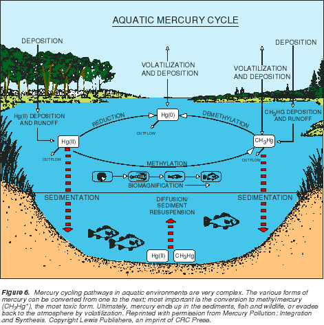
mercury cycleAquatic Mercury Cycle

At right, Figure 6 shows a schematic drawing of mercury cycling in an aquatic ecosystem.1 With the exception of isolated cases of known point sources, the ultimate source of mercury to most aquatic ecosystems is deposition from the atmosphere, primarily associated with rainfall.

As depicted in this figure, atmospheric deposition contains the three principal forms of mercury, although the majority is as inorganic mercury (Hg2+, ionic mercury). Once in surface water, mercury enters a complex cycle in which one form can be converted to another. It can be brought to the sediments by particle settling and then later released by diffusion or resuspension. It can enter the food chain, or it can be released back to the atmosphere by volatilization.

The concentration of dissolved organic carbon (DOC) and pH have a strong effect on the ultimate fate of mercury in an ecosystem. Studies have shown that for the same species of fish taken from the same region, increasing the acidity of the water (decreasing pH) and/or the DOC content generally results in higher body burdens in fish. Many scientists currently think that higher acidity and DOC levels enhance the mobility of mercury in the environment, thus making it more likely to enter the food chain.

Many of the details of the aquatic mercury cycle are still unknown, however, and remain areas of active research.

How does mercury enter the food chain?

The exact mechanism(s) by which mercury enters the food chain remain largely unknown, and probably vary among ecosystems. We do know, however, that certain bacteria play an important early role. Studies have shown that bacteria that process sulfate (SO4=) in the environment take up mercury in its inorganic form, and through metabolic processes convert it to methylmercury. The conversion of inorganic mercury to methylmercury is important for two reasons: (1) methylmercury is much more toxic than inorganic mercury, and (2) organisms require considerably longer to eliminate methylmercury. At this point, the methylmercury-containing bacteria may be consumed by the next higher level in the food chain, or the bacteria may release the methylmercury to the water where it can quickly adsorb to plankton, which are also consumed by the next level in the food chain.

Where does atmospheric mercury come from?

There are many sources of mercury to the environment, both natural and man related. Natural sources include volcanoes, natural mercury deposits, and volatilization from the ocean. The primary human-related sources include: coal combustion, chlorine alkali processing, waste incineration, and metal processing. Best estimates to date suggest that human activities have about doubled or tripled the amount of mercury in the atmosphere, and the atmospheric burden is increasing by about 1.5 percent per year.

Has there always been mercury contamination, or is this a recent problem?

This is a difficult question to answer, in part because of a lack of adequately preserved fish specimens of preindustrial age to compare against contemporary samples. However, several lines of evidence from recent studies on Wisconsin lakes suggest that increase pemissions to the atmosphere, and subsequent higher deposition rates to lakes, likely translate into higher mercury levels in fish. Although the total amount of mercury delivered to one of these lakes annually is very small it is strongly absorbed by organic material floating in the water such as plankton or bacteria. These microorganisms are consumed by organisms higher in the food chain, or after dying, settle to the bottom of the lake and are incorporated into bottom sediments. Studies of sediment cores show that younger sediments deposited since industrialization have mercury concentrations that are about 3-5 times that of historical sediments. Thus, the fact that these sediments are primarily composed of dead microorganisms that were once the bottom of the food chain would suggest that modern levels of mercury in the food chain are elevated over preindustrial times.

If human-related emissions could be eliminated or reduced, how long would it take for ecosystems to recover?

The only way to attempt to answer this question is to incorporate all the best information currently available on how mercury behaves in the environment into a computer model. Such a model was constructed as part of the research effort on northern Wisconsin lakes. Modeled scenarios predict that if emissions could be reduced by 5 percent, it would take 8 years before any change in fish concentrations would be observed, and the decrease would be small.

FS 216-95

Read a more complete explanation of the mercury cycle:

USFS Fact Sheet FS 216-95, Mercury Contamination of Aquatic Ecosystems, by Dave Krabbenhoft and David Rickert (1995).


References

1) Figure 6 reprinted with permission from Mercury Pollution: Integration and Synthesis. Copyright Lewis Publishers, an imprint of CRC Press.


Accessibility FOIA Privacy Policies and Notices

Take Pride in America logo USA.gov logo U.S. Department of the Interior | U.S. Geological Survey
URL: http://wi.water.usgs.gov/mercury/mercury-cycling.html
Page Contact Information: webmaster@wi.water.usgs.gov
Page Last Modified: Friday, 17-Oct-2008 15:23:45 EDT

04027500: Flow=118cfs,Stage=0.94ft,2012-02-09 19:15,Low,WHITE RIVER NEAR ASHLAND, WI 04062000: Flow=207cfs,Stage=3.80ft,2012-02-09 20:30,>90,PAINT RIVER NEAR ALPHA, MI 05391000: Flow=524cfs,Stage=1.84ft,2012-02-09 21:00,<10,WISCONSIN RIVER @ RAINBOW LAKE NR LAKE TOMAHAWK,WI 05436500: Flow=344cfs,Stage=1.18ft,Floodstage=5ft,2012-02-09 19:00,76-90,SUGAR RIVER NEAR BRODHEAD, WI 05430500: Flow=2110cfs,2012-02-09 19:00,Stage=4.71ft,2012-02-09 21:15:00,Floodstage=9ft,76-90,ROCK RIVER AT AFTON, WI 05427570: Flow=1540cfs,Stage=11.90ft,2012-02-09 21:00,76-90,ROCK RIVER AT INDIANFORD, WI 05423500: Flow=20cfs,Stage=2.25ft,Floodstage=6ft,2012-02-09 19:00,76-90,SOUTH BRANCH ROCK RIVER AT WAUPUN, WI 05414820: Flow=25cfs,Stage=4.81ft,2012-02-09 21:15,76-90,SINSINAWA RIVER NEAR MENOMINEE, IL 05405000: Flow=373cfs,Stage=7.77ft,Floodstage=16ft,2012-02-09 21:00,76-90,BARABOO RIVER NEAR BARABOO, WI 04087120: Flow=80cfs,Stage=2.00ft,Floodstage=11ft,2012-02-09 21:00,76-90,MENOMONEE RIVER AT WAUWATOSA, WI 04063000: Flow=1820cfs,2012-02-09 22:00,Stage=4.45ft,2012-02-09 21:00:00,Floodstage=9ft,76-90,MENOMINEE RIVER NEAR FLORENCE, WI 05398000: Flow=1730cfs,Stage=13.17ft,Floodstage=25ft,2012-02-09 21:00,10-24,WISCONSIN RIVER AT ROTHSCHILD, WI 05395000: Flow=1550cfs,Stage=4.48ft,Floodstage=11ft,2012-02-09 21:00,10-24,WISCONSIN RIVER AT MERRILL, WI 05394500: Flow=71cfs,2012-02-09 22:00,Stage=1.96ft,2012-02-09 21:00:00,Floodstage=7ft,10-24,PRAIRIE RIVER NEAR MERRILL, WI 04087257: Flow=5.1cfs,Stage=1.97ft,2012-02-09 19:00,10-24,PIKE RIVER NEAR RACINE, WI 04037500: Flow=14cfs,2012-02-09 23:00,Stage=4.31ft,2012-02-09 22:00:00,10-24,CISCO BRANCH ONTONAGON R AT CISCO LAKE OUTLET, MI 05548280: Flow=127cfs,Stage=4.39ft,2012-02-09 21:30,25-75,NIPPERSINK CREEK NEAR SPRING GROVE, IL 05544200: Flow=39cfs,Stage=2.37ft,Floodstage=5ft,2012-02-09 19:15,25-75,MUKWONAGO RIVER AT MUKWONAGO, WI 05543830: Flow=98cfs,Stage=3.12ft,2012-02-09 19:15,25-75,FOX RIVER AT WAUKESHA, WI 05527800: Flow=71cfs,Stage=2.93ft,Floodstage=7ft,2012-02-09 21:30,25-75,DES PLAINES RIVER AT RUSSELL, IL 05437500: Flow=4270cfs,Stage=4.33ft,2012-02-09 21:30,25-75,ROCK RIVER AT ROCKTON, IL 05433000: Flow=134cfs,Stage=4.36ft,Floodstage=11ft,2012-02-09 19:00,25-75,EAST BRANCH PECATONICA RIVER NR BLANCHARDVILLE, WI 05431486: Flow=125cfs,Stage=4.01ft,Floodstage=8ft,2012-02-09 19:00,25-75,TURTLE CREEK AT CARVERS ROCK ROAD NEAR CLINTON, WI 05430175: Flow=432cfs,Stage=4.36ft,Floodstage=10ft,2012-02-09 19:00,25-75,YAHARA RIVER NEAR FULTON, WI 05430150: Flow=92cfs,Stage=4.75ft,2012-02-09 19:00,25-75,BADFISH CREEK NEAR COOKSVILLE, WI 05427965: Flow=0.20cfs,Stage=0.43ft,2012-02-09 18:00,25-75,SPRING HARBOR STORM SEWER AT MADISON, WI 05427948: Flow=2.4cfs,Stage=3.42ft,2012-02-09 21:00,25-75,PHEASANT BRANCH AT MIDDLETON, WI 05407000: Flow=6670cfs,Stage=1.80ft,Floodstage=9ft,2012-02-09 21:00,25-75,WISCONSIN RIVER AT MUSCODA, WI 05406500: Flow=35cfs,Stage=2.02ft,Floodstage=7ft,2012-02-09 21:00,25-75,BLACK EARTH CREEK AT BLACK EARTH, WI 05404000: Flow=5060cfs,Stage=3.85ft,Floodstage=16ft,2012-02-09 21:30,25-75,WISCONSIN RIVER NEAR WISCONSIN DELLS, WI 05370000: Flow=15cfs,Stage=12.26ft,2012-02-09 19:00,25-75,EAU GALLE RIVER AT SPRING VALLEY, WI 05369000: Flow=856cfs,Stage=6.32ft,2012-02-09 19:15,25-75,RED CEDAR RIVER AT MENOMONIE, WI 05365500: Flow=2000cfs,Stage=3.34ft,2012-02-09 21:00,25-75,CHIPPEWA RIVER AT CHIPPEWA FALLS, WI 05360500: Flow=847cfs,Stage=5.49ft,2012-02-09 21:00,25-75,FLAMBEAU RIVER NEAR BRUCE, WI 05356000: Flow=600cfs,Stage=4.91ft,Floodstage=11ft,2012-02-09 19:00,25-75,CHIPPEWA RIVER AT BISHOPS BRIDGE NEAR WINTER, WI 05340500: Flow=2140cfs,Stage=2.89ft,2012-02-09 21:00,25-75,ST. CROIX RIVER AT ST. CROIX FALLS, WI 04087240: Flow=99cfs,Stage=2.85ft,2012-02-09 19:00,25-75,ROOT RIVER AT RACINE, WI 04087233: Flow=29cfs,Stage=2.79ft,Floodstage=9ft,2012-02-09 19:45,25-75,ROOT RIVER CANAL NEAR FRANKLIN, WI 04087220: Flow=17cfs,Stage=2.17ft,Floodstage=8ft,2012-02-09 21:00,25-75,ROOT RIVER NEAR FRANKLIN, WI 04087204: Flow=9.7cfs,Stage=2.46ft,Floodstage=8ft,2012-02-09 19:15,25-75,OAK CREEK AT SOUTH MILWAUKEE, WI 04087088: Flow=5.3cfs,Stage=4.49ft,2012-02-09 21:00,25-75,UNDERWOOD CREEK AT WAUWATOSA, WI 04060500: Flow=56cfs,Stage=4.18ft,Floodstage=11ft,2012-02-09 21:30,25-75,IRON RIVER AT CASPIAN, MI 464646092052900: Stage=600.55ft,2012-02-09 19:20:00,Not ranked,Rating being developed or revised,SUPERIOR BAY DULUTH SHIP CANAL AT DULUTH, MN 450659091441401: Flow=0.001800cfs,Stage=0.020ft,2012-02-09 19:00,Not ranked,DISCOVERY FARMS-RED CEDAR WATERWAY 4 NR COLFAX, WI 450654091441501: Flow=0.000000cfs,Stage=-0.013ft,2012-02-09 19:00,Not ranked,DISCOVERY FARMS-RED CEDAR WATERWAY 3 NR COLFAX, WI 450618091444001: Flow=61.740000cfs,Stage=3.000ft,2012-02-09 19:00,Not ranked,DISCOVERY FARMS-RED CEDAR WATERWAY 2 NR COLFAX, WI 450615091444001: Flow=0.397200cfs,Stage=0.415ft,2012-02-09 19:00,Not ranked,DISCOVERY FARMS-RED CEDAR WATERWAY 1 NR COLFAX, WI 450456092225801: Flow=0.000000cfs,Stage=0.008ft,2012-02-09 21:00,Not ranked,DISCOVERY FARMS-WILLOW WATERWAY 1 NEAR CYLON, WI 450115092180101: Flow=0.007220cfs,Stage=0.016ft,2012-02-09 21:00,Not ranked,DISCOVERY FARMS-WILLOW WATERWAY 2 NR WOODVILLE, WI 440531087390800: 2011-11-17 07:30,Not ranked,LAKE MICHIGAN AT MANITOWOC MARINA AT MANITOWOC,WI 434928088553601: Stage=6.10ft,2012-02-09 21:00,Not ranked,GREEN LAKE AT COUNTY TRUNK HWY A NR GREEN LAKE, WI 434425090462401: Flow=0.000000cfs,Stage=-0.004ft,2012-02-09 21:00,Not ranked,DISCOVERY FARMS-JERSEY WATERWAY 6 AT CASHTON, WI 434311090461401: Flow=0.004950cfs,Stage=0.010ft,2012-02-09 21:00,Not ranked,DISCOVERY FARMS-JERSEY WATERWAY 4 NEAR CASHTON, WI 434250090461401: Flow=0.000000cfs,Stage=-0.013ft,2012-02-09 21:00,Not ranked,DISCOVERY FARMS-JERSEY WATERWAY 5 NEAR CASHTON, WI 434244090470802: Flow=0.000000cfs,Stage=-0.008ft,2012-02-09 21:00,Not ranked,DISCOVERY FARMS-JERSEY WATERWAY 3 NEAR CASHTON, WI 434244090470801: Flow=0.000000cfs,Stage=-0.005ft,2012-02-09 21:00,Not ranked,DISCOVERY FARMS-JERSEY WATERWAY 2 NEAR CASHTON, WI 434209090491101: Flow=0.000000cfs,Stage=-0.001ft,2012-02-09 21:00,Not ranked,DISCOVERY FARMS-JERSEY WATERWAY 1 NEAR CASHTON, WI 434034088252401: Flow=0.000000cfs,Stage=0.023ft,2012-02-09 13:00,Not ranked,SCF W BR MILWAUKEE RIVER WATERWAY 1 NEAR BYRON, WI 433727088215801: Flow=0.005870cfs,Stage=0.019ft,2012-02-09 21:00,Not ranked,SCF W BR MILWAUKEE RIVER WATERWAY 2 NR ASHFORD, WI 431250089282901: Flow=0.000000cfs,Stage=0.014ft,2012-02-09 21:30,Not ranked,DANE COUNTY MRBI WATERWAY NUMBER 1 NR WAUNAKEE, WI 431212089314801: Stage=0.031ft,2012-02-09 21:00:00,Not ranked,Rating being developed or revised,DANE CO MRBI WATERWAY 2 NR SPRINGFIELD CORNERS, WI 431208089314901: Stage=0.164ft,2012-02-09 21:00:00,Not ranked,Rating being developed or revised,DANE CO. MRBI TILE #1 NEAR SPRINGFIELD CORNERS, WI 430402089183501: Stage=31.90ft,2012-02-09 19:01:00,Not ranked,Rating being developed or revised,US HWY 51 WISDOT GRASS SWALES DOWNSTRM MADISON, WI 430356089183502: Stage=-0.63ft,2012-02-09 19:00:00,Not ranked,Rating being developed or revised,US HWY 51 WISDOT GRASS SWALES MIDDLE MADISON, WI 425715089164700: Stage=2.40ft,2012-02-09 21:15,Not ranked,LAKE KEGONSA AT BARBER DRIVE NEAR STOUGHTON, WI 424848088083100: Stage=7.74ft,2012-02-09 21:15,Not ranked,WIND LAKE AT OUTLET AT WIND LAKE, WI 423525088260400: Stage=2.52ft,2012-02-09 19:30,Not ranked,GENEVA LAKE AT LAKE GENEVA, WI 055451345: Flow=34cfs,Stage=8.70ft,2012-02-09 19:30,Not ranked,WHITE RIVER AT CENTER STREET AT LAKE GENEVA, WI 054279465: Flow=0.65cfs,Stage=2.10ft,2012-02-09 21:00,Not ranked,S FORK PHEASANT BRANCH @ DEMING WAY @ MIDDLETON,WI 054041665: Stage=5.27ft,2012-02-09 21:30:00,Not ranked,Ice affected,BARABOO RIVER AT MAIN STREET AT REEDSBURG, WI 053813595: Stage=35.99ft,2012-02-09 21:00:00,Floodstage=47ft,Not ranked,Ice affected,BLACK RIVER DS ST HWY 54 AT BLACK RIVER FALLS, WI 053674962: Flow=0.59cfs,Stage=1.69ft,2012-02-09 21:45,Not ranked,TROUT CREEK AT CNTY TRUNK HIGHWAY DD NR BLOOMER,WI 053416972: Flow=36cfs,Stage=3.83ft,2012-02-09 21:00,Not ranked,WILLOW RIVER @ COUNTY TRUNK HIGHWAY T AT JEWETT,WI 053416966: Stage=3.02ft,2012-02-09 21:00:00,Not ranked,Ice affected,DRY RUN AT 190TH STREET NEAR JEWETT, WI 040871488: Flow=3.9cfs,2012-02-09 21:50,Stage=11.01ft,2012-02-09 20:50:00,Not ranked,WILSON PARK CR @ ST. LUKES HOSPTL @ MILWAUKEE, WI 040871476: Flow=0.00cfs,2012-02-09 21:00,Stage=0.10ft,2012-02-09 20:00:00,Not ranked,HOLMES AVE CR TRB @ GMIA OUTFALL #1 @ MILWAUKEE,WI 040871475: Flow=0.65cfs,Stage=10.85ft,2012-02-09 21:55,Not ranked,WILSON PARK CREEK @ GMIA OUTFALL #7 @ MILWAUKEE,WI 040871473: Flow=0.21cfs,Stage=10.65ft,2012-02-09 20:00,Not ranked,WILSON PARK CREEK AT GMIA INFALL AT MILWAUKEE, WI 040869416: Stage=3.56ft,2012-02-09 16:00:00,Not ranked,Ice affected,LINCOLN CREEK @ SHERMAN BOULEVARD AT MILWAUKEE, WI 040857005: 0000-00-00 00:00,Stage=4.41ft,2012-02-09 21:00:00,Not ranked,OTTER CREEK AT WILLOW ROAD NEAR PLYMOUTH, WI 040854592: Stage=3.71ft,2012-02-09 21:00:00,Not ranked,Rating being developed or revised,FISHER CREEK AT HOWARDS GROVE, WI 040851385: Flow=2950cfs,Stage=577.52ft,Floodstage=584ft,2012-02-09 22:00,Not ranked,FOX RIVER AT OIL TANK DEPOT AT GREEN BAY, WI 040851325: Flow=4.4cfs,Stage=2.20ft,2012-02-09 21:15,Not ranked,BAIRD CREEK AT SUPERIOR ROAD AT GREEN BAY, WI 040263205: Flow=17cfs,Stage=1.27ft,Floodstage=5ft,2012-02-09 21:10,Not ranked,WHITTLESEY CREEK NEAR ASHLAND, WI 05548170: Flow=39cfs,Stage=2.26ft,2012-02-09 21:45,Not ranked,NORTH BRANCH NIPPERSINK CREEK AT GENOA CITY, WI 05548000: Stage=2.51ft,2012-02-09 21:30,Not ranked,NIPPERSINK LAKE AT FOX LAKE, IL 05547500: Stage=2.65ft,2012-02-09 21:45,Not ranked,FOX LAKE NEAR LAKE VILLA, IL 05547000: 2012-02-09 21:45,Not ranked,CHANNEL LAKE NEAR ANTIOCH, IL 05545750: Flow=463cfs,Stage=6.49ft,Floodstage=10ft,2012-02-09 21:15,Not ranked,FOX RIVER NEAR NEW MUNSTER, WI 05544475: Stage=1.59ft,Floodstage=7.5ft,2012-02-09 21:15,Not ranked,FOX RIVER AT ROCHESTER, WI 05544385: Stage=11.81ft,2012-02-09 21:45,Not ranked,MUSKEGO (BIG MUSKEGO) LAKE OUTLET NR WIND LAKE, WI 05527950: Flow=47cfs,Stage=7.14ft,2012-02-09 21:30,Not ranked,MILL CREEK AT OLD MILL CREEK, IL 05527910: Flow=24cfs,Stage=17.36ft,2012-02-09 21:30,Not ranked,NORTH MILL CREEK NEAR MILBURN, IL 05527905: Flow=5.8cfs,Stage=11.42ft,2012-02-09 21:30,Not ranked,HASTINGS CREEK NEAR LINDENHURST, IL 05527900: Flow=54cfs,Stage=8.25ft,2012-02-09 21:30,Not ranked,NORTH MILL CREEK AT HICKORY CORNERS, IL 05438283: Flow=2.7cfs,Stage=4.72ft,2012-02-09 19:00,Not ranked,PISCASAW CREEK NEAR WALWORTH, WI 05437050: Flow=1840cfs,Stage=6.17ft,Floodstage=12ft,2012-02-09 21:15,Not ranked,PECATONICA RIVER NR SHIRLAND, ILL 05435950: Flow=36cfs,Stage=3.03ft,2012-02-09 21:00,Not ranked,SUGAR RIVER NEAR VERONA, WI 05435943: Flow=11cfs,Stage=4.45ft,2012-02-09 19:00,Not ranked,BADGER MILL CREEK AT VERONA, WI 05434500: Stage=5.19ft,2012-02-09 19:45:00,Floodstage=13.5ft,Not ranked,Ice affected,PECATONICA RIVER AT MARTINTOWN, WI 05432927: Flow=10cfs,Stage=10.05ft,2012-02-09 21:15,Not ranked,PLEASANT VALLEY CREEK @ CTH H NR BLANCHARDVILLE,WI 05432695: Flow=12cfs,Stage=7.73ft,2012-02-09 21:00,Not ranked,RIDGEWAY BRANCH NEAR HOLLANDALE, WI 05432500: Stage=2.60ft,Floodstage=13.5ft,2012-02-09 21:00,Not ranked,PECATONICA RIVER AT DARLINGTON, WI 05429700: Flow=268cfs,Stage=6.32ft,2012-02-09 21:25,Not ranked,YAHARA RIVER @ FORTON STREET BRIDGE @ STOUGHTON,WI 05429510: Not ranked,Equipment malfunction,YAHARA RIVER @ EXCHANGE ST. BRIDGE @ MC FARLAND,WI 05429500: Stage=4.07ft,2012-02-09 21:15:00,Not ranked,Ice affected,YAHARA RIVER AT MC FARLAND, WI 05429485: Stage=4.09ft,2012-02-09 21:15,Not ranked,LAKE WAUBESA AT MC FARLAND, WI 05429000: Stage=4.28ft,2012-02-09 21:00,Not ranked,LAKE MONONA AT MADISON, WI 05428500: Flow=130cfs,Stage=4.42ft,2012-02-09 21:20,Not ranked,YAHARA RIVER AT EAST MAIN STREET AT MADISON, WI 05428000: Stage=8.44ft,2012-02-09 21:15,Not ranked,LAKE MENDOTA AT MADISON, WI 05427943: Flow=1.4cfs,2012-02-09 22:00,Stage=2.99ft,2012-02-09 21:00:00,Not ranked,PHEASANT BRANCH AT AIRPORT ROAD NEAR MIDDLETON, WI 05427850: Flow=72cfs,Stage=8.57ft,2012-02-09 21:30,Not ranked,YAHARA RIVER AT STATE HIGHWAY 113 AT MADISON, WI 05427718: Flow=22cfs,Stage=1.21ft,2012-02-09 21:00,Not ranked,YAHARA RIVER AT WINDSOR, WI 05427530: Flow=1010cfs,Stage=2.58ft,2012-02-09 21:00,Not ranked,ROCK RIVER AT NEWVILLE, WI 05427235: Stage=6.34ft,Floodstage=10ft,2012-02-09 19:00,Not ranked,LAKE KOSHKONONG NEAR NEWVILLE, WI 05427085: Stage=1.47ft,2012-02-09 18:55:00,Floodstage=6ft,Not ranked,Ice affected,ROCK RIVER AT ROBERT STREET AT FORT ATKINSON, WI 05426250: Stage=2.01ft,2012-02-09 19:00:00,Floodstage=3ft,Not ranked,Ice affected,BARK RIVER NEAR ROME, WI 05426067: Stage=12.57ft,2012-02-09 21:15:00,Not ranked,Ice affected,BARK RIVER AT NAGAWICKA ROAD AT DELAFIELD, WI 05426000: Stage=2.72ft,2012-02-09 21:00:00,Not ranked,Ice affected,CRAWFISH RIVER AT MILFORD, WI 05425912: Flow=101cfs,Stage=839.85ft,Floodstage=843.5ft,2012-02-09 21:00,Not ranked,BEAVERDAM RIVER AT BEAVER DAM, WI 05425500: Stage=2.42ft,2012-02-09 19:15:00,Floodstage=5.5ft,Not ranked,Ice affected,ROCK RIVER AT WATERTOWN, WI 05424057: Flow=256cfs,Stage=6.94ft,Floodstage=8.5ft,2012-02-09 19:15,Not ranked,ROCK RIVER AT HORICON, WI 05424000: Not ranked,Site discontinued,EAST BRANCH ROCK RIVER NEAR MAYVILLE, WI 05423510: Not ranked,Site discontinued,WEST BRANCH ROCK RIVER @ STATE HWY 49 NR WAUPUN,WI 05414000: Stage=3.34ft,Floodstage=9ft,2012-02-09 21:00,Not ranked,PLATTE RIVER NEAR ROCKVILLE, WI 05413500: Stage=5.49ft,2012-02-09 21:00:00,Floodstage=18ft,Not ranked,Ice affected,GRANT RIVER AT BURTON, WI 05411500: Stage=11.68ft,2012-02-09 21:45,Not ranked,Mississippi River at Clayton, IA 05410490: Flow=507cfs,Stage=6.81ft,Floodstage=12ft,2012-02-09 21:45,Not ranked,KICKAPOO RIVER AT STEUBEN, WI 05408480: Flow=1.4cfs,Stage=2.68ft,2012-02-09 21:00,Not ranked,W FORK KICKAPOO R @ PEACEFUL VAL RD NR CASHTON, WI 05408476: Flow=0.00cfs,Stage=0.00ft,2012-02-09 21:00,Not ranked,WEST FORK KICKAPOO RIVER @ OGDEN AVE AT CASHTON,WI 05408000: Stage=3.19ft,2012-02-09 21:00:00,Floodstage=15ft,Not ranked,Ice affected,KICKAPOO RIVER AT LA FARGE, WI 05407470: Flow=79cfs,Stage=8.69ft,Floodstage=16ft,2012-02-09 19:45,Not ranked,KICKAPOO RIVER AT STATE HIGHWAY 33 AT ONTARIO, WI 05406457: Flow=9.6cfs,Stage=1.98ft,2012-02-09 21:00,Not ranked,BLACK EARTH CREEK NR BREWERY RD @ CROSS PLAINS, WI 05404500: Stage=7.31ft,2012-02-09 19:00,Not ranked,DEVILS LAKE NEAR BARABOO, WI 05404116: Flow=21cfs,Stage=4.85ft,Floodstage=13ft,2012-02-09 19:15,Not ranked,WEST BRANCH BARABOO RIVER AT HILLSBORO, WI 05403500: Stage=2.81ft,2012-02-09 21:00:00,Not ranked,Ice affected,LEMONWEIR RIVER AT NEW LISBON, WI 05403000: Stage=9.69ft,2012-02-09 21:00:00,Not ranked,Ice affected,YELLOW RIVER AT NECEDAH, WI 05402000: Stage=2.07ft,2012-02-09 19:15:00,Floodstage=12ft,Not ranked,Ice affected,YELLOW RIVER AT BABCOCK, WI 05401556: Flow=72cfs,Stage=10.73ft,2012-02-09 21:30,Not ranked,BIG ROCHE A CRI CREEK @ STATE HWY 21 NR ARKDALE,WI 05401050: Stage=4.62ft,2012-02-09 19:45:00,Not ranked,Ice affected,TENMILE CREEK NEAR NEKOOSA, WI 05400718: Flow=15cfs,Stage=2.53ft,2012-02-09 21:30,Not ranked,MILL CREEK @ COUNTY TRUNK HIGHWAY PP NR PLOVER, WI 05400513: Flow=114cfs,Stage=3.15ft,2012-02-09 21:30,Not ranked,PLOVER RIVER AT HIGHWAY 66 AT STEVENS POINT, WI 05400220: Stage=3.24ft,2012-02-09 21:30:00,Not ranked,Ice affected,LITTLE EAU PLEINE RIVER NEAR ROZELLVILLE, WI 05399580: Stage=3.20ft,2012-02-09 21:45:00,Not ranked,Ice affected,FREEMAN CREEK AT HALDER, WI 05399550: Stage=4.26ft,2012-02-09 21:00:00,Not ranked,Ice affected,FENWOOD CREEK AT BRADLEY, WI 05399500: Stage=2.88ft,2012-02-09 21:00:00,Floodstage=15.5ft,Not ranked,Ice affected,BIG EAU PLEINE RIVER AT STRATFORD, WI 05397500: Stage=1.46ft,2012-02-09 21:00:00,Floodstage=7ft,Not ranked,Ice affected,EAU CLAIRE RIVER AT KELLY, WI 05396000: Stage=2.47ft,2012-02-09 21:00:00,Floodstage=10ft,Not ranked,Ice affected,BIG RIB RIVER AT RIB FALLS, WI 05395063: Stage=3.90ft,2012-02-09 21:30:00,Not ranked,Ice affected,PINE RIVER AT CENTER AVENUE NEAR MERRILL, WI 05393500: Stage=1.65ft,2012-02-09 21:00:00,Not ranked,Ice affected,SPIRIT RIVER AT SPIRIT FALLS, WI 05390685: Stage=11.13ft,2012-02-09 21:15:00,Not ranked,Ice affected,MUSKELLUNGE CREEK NEAR ST. GERMAIN, WI 05390500: Stage=90.24ft,2012-02-09 21:30,Not ranked,ANVIL LAKE NEAR EAGLE RIVER, WI 05390100: Stage=79.73ft,Floodstage=82ft,2012-02-09 21:00,Not ranked,LAC VIEUX DESERT NEAR LAND O\'LAKES, WI 05389500: Flow=14500cfs,2012-02-09 15:00,Stage=7.81ft,2012-02-09 21:00:00,Floodstage=16ft,Not ranked,Mississippi River at McGregor, IA 05389400: Flow=21cfs,Stage=4.33ft,2012-02-09 21:00,Not ranked,Bloody Run Creek near Marquette, IA 05389000: Flow=55cfs,Stage=4.74ft,2012-02-09 21:45,Not ranked,Yellow River near Ion, IA 05388410: Stage=13.30ft,Floodstage=625ft,2012-02-09 20:00,Not ranked,Mississippi Riv at Lock and Dam 9 nr Lynxville, WI 05386400: Stage=30.98ft,2012-02-09 21:00,Not ranked,MISSISSIPPI RIVER AT BROWNSVILLE, MN 05383075: Stage=2.58ft,2012-02-09 19:00:00,Not ranked,Ice affected,LA CROSSE RIVER NEAR LA CROSSE, WI 05382325: Flow=131cfs,Stage=3.32ft,2012-02-09 19:00,Not ranked,LA CROSSE RIVER AT SPARTA, WI 05382284: Stage=5.22ft,2012-02-09 19:05:00,Not ranked,Ice affected,SILVER CREEK AT STATE HIGHWAY 21 NEAR ANGELO, WI 05382267: Flow=51cfs,Stage=5.94ft,2012-02-09 19:00,Not ranked,LA CROSSE RIVER @ CNTY TRUNK HIGHWY BB NR TOMAH,WI 05382257: Flow=1.3cfs,Stage=2.40ft,2012-02-09 19:00,Not ranked,STILLWELL CREEK AT YARD ROAD NEAR TOMAH, WI 05382255: Flow=1.2cfs,Stage=2.33ft,2012-02-09 19:00,Not ranked,STILLWELL CREEK AT 16TH COURT NEAR TOMAH, WI 05382000: Stage=2.90ft,2012-02-09 21:30:00,Floodstage=12ft,Not ranked,Ice affected,BLACK RIVER NEAR GALESVILLE, WI 05381000: Stage=3.62ft,2012-02-09 19:15:00,Floodstage=18ft,Not ranked,Ice affected,BLACK RIVER AT NEILLSVILLE, WI 05380509: Stage=1.86ft,2012-01-12 19:00,Not ranked,TANK CREEK NEAR GALESVILLE, WI 05379500: Stage=5.47ft,2012-02-09 21:00:00,Floodstage=9ft,Not ranked,Ice affected,TREMPEALEAU RIVER AT DODGE, WI 05378500: Stage=5.51ft,Floodstage=13ft,2012-02-09 21:00,Not ranked,Very low value,MISSISSIPPI RIVER AT WINONA, MN 05378490: Stage=5.68ft,2012-02-09 21:00,Not ranked,MISSISSIPPI RIVER AT LOCK AND DAM 5A NR WINONA, MN 05369500: Stage=3.11ft,2012-02-09 21:15:00,Floodstage=13ft,Not ranked,Ice affected,CHIPPEWA RIVER AT DURAND, WI 05368000: Stage=3.56ft,2012-02-09 19:00:00,Not ranked,Ice affected,HAY RIVER AT WHEELER, WI 05364422: Flow=0.15cfs,Stage=1.99ft,2012-02-09 21:45,Not ranked,COMO CREEK TRIBUTARY NEAR BLOOMER, WI 05362000: Stage=3.77ft,2012-02-09 19:15:00,Not ranked,Ice affected,JUMP RIVER AT SHELDON, WI 05357335: Flow=35cfs,Stage=3.72ft,2012-02-09 21:00,Not ranked,BEAR RIVER NEAR MANITOWISH WATERS, WI 05357245: Flow=32cfs,Stage=1.10ft,2012-02-09 05:15,Not ranked,TROUT RIVER AT TROUT LAKE NEAR BOULDER JUNCTION,WI 05357230: Flow=2.0cfs,Stage=7.73ft,2012-01-17 12:30,Not ranked,NORTH CREEK AT TROUT LAKE NEAR BOULDER JUNCTION,WI 05357225: Stage=8.13ft,2012-02-09 17:15:00,Not ranked,Ice affected,STEVENSON CREEK @ CT HWY M NR BOULDER JUNCTION, WI 05357215: Flow=9.2cfs,Stage=1.43ft,2012-01-17 11:45,Not ranked,ALLEQUASH CREEK @ CT HWY M NR BOULDER JUNCTION, WI 05357206: Flow=3.0cfs,Stage=2.55ft,2012-02-09 17:30,Not ranked,ALLEQUASH CREEK SITE NO. 3 NR BOULDER JUNCTION, WI 05356500: Stage=3.25ft,2012-02-09 21:00:00,Not ranked,Ice affected,CHIPPEWA RIVER NEAR BRUCE, WI 05346050: Stage=668.05ft,2012-02-09 21:30,Not ranked,CLEAR LAKE, EAST SIDE, AT PRAIRIE ISLAND, MN 05344850: 2012-02-09 21:45,Not ranked,STURGEON LAKE, WEST SIDE, AT PRAIRIE ISLAND, MN 05344500: Stage=25.10ft,2012-02-09 21:00,Not ranked,Very low value,MISSISSIPPI RIVER AT PRESCOTT, WI 05344490: Stage=25.20ft,2012-02-09 21:30:00,Not ranked,Equipment malfunction,ST. CROIX RIVER AT PRESCOTT, WI 05342000: Flow=106cfs,Stage=9.84ft,2012-02-09 21:00,Not ranked,KINNICKINNIC RIVER NEAR RIVER FALLS, WI 05341694: Flow=6.9cfs,Stage=4.35ft,2012-02-09 21:00,Not ranked,SOUTH FORK WILLOW RIVER AT US HWY 63 NEAR CYLON,WI 05341687: Stage=4.91ft,2012-02-09 21:00:00,Not ranked,Ice affected,WILLOW RIVER AT STATE HIGHWAY 46 NEAR DEER PARK,WI 05333500: Stage=2.20ft,2012-02-09 19:30:00,Floodstage=7ft,Not ranked,Ice affected,ST. CROIX RIVER NEAR DANBURY, WI 05331833: Stage=1.57ft,2012-02-09 19:30:00,Not ranked,Ice affected,NAMEKAGON RIVER AT LEONARDS, WI 04087214: Stage=10.60ft,2012-02-09 16:00:00,Not ranked,Ice affected,ROOT RIVER AT GRANGE AVENUE AT GREENFIELD, WI 04087170: Stage=6.53ft,2012-02-09 21:05,Not ranked,MILWAUKEE RIVER AT MOUTH AT MILWAUKEE, WI 04087159: Flow=5.0cfs,Stage=6.10ft,Floodstage=16ft,2012-02-09 21:30,Not ranked,KINNICKINNIC RIVER @ S. 11TH STREET @ MILWAUKEE,WI 04087142: Flow=-239cfs,Stage=10.97ft,2012-02-09 21:30,Not ranked,MENOMONEE RIVER AT 16TH STREET AT MILWAUKEE, WI 04087119: Stage=5.88ft,2012-02-09 21:30:00,Not ranked,Ice affected,HONEY CREEK AT WAUWATOSA, WI 04087070: Stage=4.14ft,2012-02-09 21:00:00,Not ranked,Ice affected,LITTLE MENOMONEE RIVER AT MILWAUKEE, WI 04087050: Stage=2.11ft,2012-02-09 21:25:00,Not ranked,Ice affected,LITTLE MENOMONEE RIVER NEAR FREISTADT, WI 04087030: Stage=3.43ft,2012-02-09 17:30:00,Floodstage=7.5ft,Not ranked,Ice affected,MENOMONEE RIVER AT MENOMONEE FALLS, WI 04087000: Stage=2.20ft,2012-02-09 21:00:00,Floodstage=7ft,Not ranked,Ice affected,MILWAUKEE RIVER AT MILWAUKEE, WI 04086600: Stage=5.98ft,2012-02-09 19:00:00,Floodstage=11ft,Not ranked,Ice affected,MILWAUKEE RIVER NEAR CEDARBURG, WI 04086500: Stage=5.88ft,2012-02-09 21:30:00,Floodstage=10ft,Not ranked,Ice affected,CEDAR CREEK NEAR CEDARBURG, WI 04086139: Stage=2.28ft,2012-02-09 21:00:00,Not ranked,Rating being developed or revised,WEST BRANCH MILWAUKEE RIVER NEAR KEWASKUM, WI 04086120: Stage=2.84ft,2012-02-09 21:00:00,Not ranked,Rating being developed or revised,WEST BRANCH MILWAUKEE RIVER @ CTH K NEAR LOMIRA,WI 04086000: Stage=2.42ft,2012-02-09 19:00:00,Floodstage=8ft,Not ranked,Ice affected,SHEBOYGAN RIVER AT SHEBOYGAN, WI 04085427: Stage=5.18ft,2012-02-09 21:30:00,Floodstage=10ft,Not ranked,Ice affected,MANITOWOC RIVER AT MANITOWOC, WI 04085200: Stage=9.16ft,2012-02-09 19:45:00,Floodstage=14ft,Not ranked,Ice affected,KEWAUNEE RIVER NEAR KEWAUNEE, WI 04084911: Stage=2.53ft,2012-02-09 21:00:00,Not ranked,Ice affected,PLUM CREEK NEAR WRIGHTSTOWN, WI 04084445: Flow=3010cfs,Stage=5.56ft,Floodstage=8.4ft,2012-02-09 19:00,Not ranked,FOX RIVER AT APPLETON, WI 04084255: Stage=1.96ft,2012-02-09 19:15,Not ranked,LAKE WINNEBAGO NEAR STOCKBRIDGE, WI 04084038: 2012-02-09 16:05,Not ranked,DE NEVEU CREEK @ E. MERRILL ST. AT FOND DU LAC, WI 04083545: Not ranked,Site discontinued,FOND DU LAC RIVER @ W. ARNDT ST. AT FOND DU LAC,WI 04082500: Stage=2.05ft,Floodstage=3.5ft,2012-02-09 19:30,Not ranked,LAKE WINNEBAGO AT OSHKOSH, WI 04082400: Flow=2470cfs,Stage=5.34ft,Floodstage=7.5ft,2012-02-09 19:00,Not ranked,FOX RIVER AT OSHKOSH, WI 04081000: Stage=1.72ft,2012-02-09 19:15:00,Floodstage=6ft,Not ranked,Ice affected,WAUPACA RIVER NEAR WAUPACA, WI 04080000: Stage=1.38ft,2012-02-09 21:00:00,Floodstage=5ft,Not ranked,Ice affected,LITTLE WOLF RIVER AT ROYALTON, WI 04079000: Stage=2.98ft,2012-02-09 21:15:00,Floodstage=9ft,Not ranked,Ice affected,WOLF RIVER AT NEW LONDON, WI 04078500: Stage=2.93ft,2012-02-09 21:00:00,Floodstage=7ft,Not ranked,Ice affected,EMBARRASS RIVER NEAR EMBARRASS, WI 04077630: Stage=5.87ft,2012-02-09 21:30:00,Not ranked,Ice affected,RED RIVER AT MORGAN ROAD NEAR MORGAN, WI 04074950: Stage=8.45ft,2012-02-09 19:00:00,Floodstage=11.5ft,Not ranked,Ice affected,WOLF RIVER AT LANGLADE, WI 04073970: Not ranked,Site discontinued,WAUKAU CREEK NEAR OMRO, WI 04073500: Stage=9.16ft,2012-02-09 19:00:00,Floodstage=13ft,Not ranked,Ice affected,FOX RIVER AT BERLIN, WI 04073473: Stage=3.43ft,2012-02-09 19:45:00,Not ranked,Ice affected,PUCHYAN RIVER DS N. LAWSON DRIVE NR GREEN LAKE, WI 04073468: Stage=6.10ft,2012-02-09 21:00:00,Not ranked,Ice affected,GREEN LAKE INLET AT CT HIGHWAY A NR GREEN LAKE, WI 04073466: Stage=6.43ft,2012-02-09 21:05:00,Not ranked,Rating being developed or revised,SILVER CREEK AT SPAULDING ROAD NEAR GREEN LAKE, WI 04073462: Stage=4.25ft,2012-02-09 21:00:00,Not ranked,Ice affected,WHITE CREEK AT SPRING GROVE ROAD NR GREEN LAKE, WI 04073365: Not ranked,Ice affected,FOX RIVER AT PRINCETON, WI 04072845: Not ranked,Site discontinued,MONTELLO RIVER NEAR MONTELLO, WI 04072150: Stage=12.08ft,2012-02-09 19:00:00,Floodstage=18ft,Not ranked,Ice affected,DUCK CREEK NEAR HOWARD, WI 04071765: Stage=4.18ft,2012-02-09 21:00:00,Floodstage=9ft,Not ranked,Ice affected,OCONTO RIVER NEAR OCONTO, WI 04071000: Stage=3.72ft,2012-02-09 15:15:00,Floodstage=7.5ft,Not ranked,Ice affected,OCONTO RIVER NEAR GILLETT, WI 04069500: Stage=1.21ft,2012-02-09 19:15:00,Floodstage=10ft,Not ranked,Ice affected,PESHTIGO RIVER AT PESHTIGO, WI 04069416: Stage=8.10ft,2012-02-09 19:35:00,Floodstage=12ft,Not ranked,Ice affected,PESHTIGO RIVER AT PORTERFIELD, WI 04067958: Stage=4.42ft,2012-02-09 19:15:00,Not ranked,Ice affected,PESHTIGO RIVER NEAR WABENO, WI 04067500: Stage=9.32ft,2012-02-09 21:00:00,Floodstage=15ft,Not ranked,Ice affected,MENOMINEE RIVER NEAR MC ALLISTER, WI 04066800: Stage=10.40ft,2012-02-09 19:45:00,Floodstage=17ft,Not ranked,Ice affected,MENOMINEE RIVER AT KOSS, MI 04066500: Stage=3.19ft,2012-02-09 19:00:00,Not ranked,Ice affected,PIKE RIVER AT AMBERG, WI 04066030: Flow=2020cfs,Stage=7.07ft,Floodstage=14ft,2012-02-09 19:00,Not ranked,MENOMINEE RIVER AT WHITE RAPIDS DAM NEAR BANAT, MI 04066003: Stage=10.75ft,2012-02-09 21:00:00,Floodstage=14ft,Not ranked,Ice affected,MENOMINEE RIVER BELOW PEMENE CREEK NR PEMBINE, WI 04065106: Flow=2150cfs,Stage=6.48ft,Floodstage=13ft,2012-02-09 21:00,Not ranked,MENOMINEE RIVER AT NIAGARA, WI 04064500: Stage=2.74ft,2012-02-09 21:00:00,Floodstage=7ft,Not ranked,Ice affected,PINE RIVER BELOW PINE R POWERPLANT NR FLORENCE, WI 04063700: Stage=2.03ft,2012-02-09 19:45:00,Floodstage=6ft,Not ranked,Ice affected,POPPLE RIVER NEAR FENCE, WI 04063500: Flow=1770cfs,Stage=7.34ft,Floodstage=12ft,2012-02-09 13:30,Not ranked,MENOMINEE RIVER AT TWIN FALLS NEAR IRON MT, MI 04062011: Flow=351cfs,Stage=6.52ft,Floodstage=12ft,2012-02-09 21:30,Not ranked,BRULE RIVER NEAR COMMONWEALTH, WI 04060993: Stage=4.97ft,2012-02-09 21:30:00,Not ranked,Ice affected,BRULE RIVER AT US HIGHWAY 2 NEAR FLORENCE, WI 04037400: Stage=3.94ft,2012-02-09 21:00,Not ranked,CISCO LAKE NEAR WATERSMEET, MI 04031000: Stage=1.33ft,2012-02-09 21:00:00,Floodstage=10ft,Not ranked,Ice affected,BLACK RIVER NEAR BESSEMER, MI 04027000: Stage=2.96ft,2012-02-09 21:45:00,Floodstage=18ft,Not ranked,Ice affected,BAD RIVER NEAR ODANAH, WI 04026561: Stage=3.54ft,2012-02-09 21:30:00,Not ranked,Ice affected,TYLER FORKS RIVER AT STRICKER ROAD NEAR MELLEN, WI 04026390: Flow=0.12cfs,Stage=4.16ft,2012-02-09 21:00,Not ranked,BEARTRAP CREEK AT U.S. HIGHWAY 2 NEAR ASHLAND, WI 04025500: Stage=1.48ft,2012-02-09 19:45:00,Floodstage=7ft,Not ranked,Ice affected,BOIS BRULE RIVER AT BRULE, WI 04024430: Stage=5.45ft,2012-02-09 19:00:00,Floodstage=20ft,Not ranked,Ice affected,NEMADJI RIVER NEAR SOUTH SUPERIOR, WI Go to WaterWatch (offsite) for a larger map with additional options