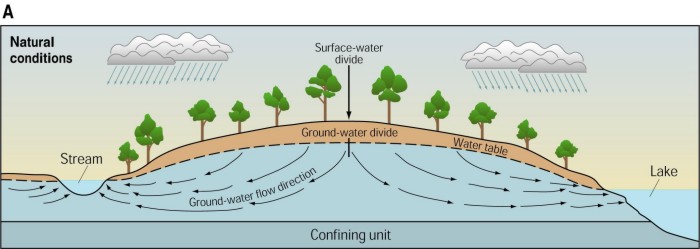
 SURFACE-WATER AND NATURAL GROUND-WATER DIVIDES SURFACE-WATER AND NATURAL GROUND-WATER DIVIDES
The boundaries of natural ground-water systems are defined by GROUND-WATER
DIVIDES that separate areas where the water flows in one direction from
areas where it flows in another. For the shallow part of the ground-water
system, the locations of divides are determined largely by the
distribution of surface-water bodies. Some of the ground water might flow
toward a stream located, say, on the west side of the basin, while the
rest flows toward a lake located on the east side of the basin:
SURFACE-WATER DIVIDES (also called "watershed divides")
are defined by land topography and separate areas where water flows overland
as runoff toward different surface-water bodies. In the schematic figure shown
above, the ground-water and surface-water divides coincide and are located along
a topographic high such as a ridgeline. However, in many real cases the two types
of divides do not coincide. In fact, as we will see in the case of southeastern
Wisconsin, under some circumstances they can fall many miles apart - even in
the absence of pumping.
A single major surface-water divide
separates areas that slope down toward the Great Lakes from areas that slope
in other directions. This boundary is called a SUBCONTINENTAL DIVIDE.
The waters of the Great Lakes include the rivers that empty into them.
Each of these rivers and their tributaries drain rain and snow that falls
on its basin. The most landward boundary of these basins generally
coincides with an identifiable ridge or other high point. On the other side of the
basin boundary, runoff from rain and snow drains into streams and rivers
that ultimately connect to other large bodies of water such as the
Mississippi River or Caribbean Sea. It is possible, using topographic maps, to
trace the basin boundaries that divide rivers that drain to the Great
Lakes from rivers that drain elsewhere. Stitched together these basin
boundaries define the surface-water subcontinental divide of the Great
Lakes Basin.
Rivers and streams are not the only way to convey rain and snowmelt to the
Great Lakes. The ground-water system also moves water in that direction.
Some of the ground-water belonging to the Great Lake system discharges
directly into one of the lakes, but most discharges to the Lakes
indirectly by discharging to a river or stream within the watershed.
It is not as easy to determine the boundary enclosing Great Lakes ground
water as it is to trace the surface-water divide. An important factor to
consider is that the location of the ground-water divide depends on depth
from the land surface. At the water-table surface or at shallow depths
below the water table, the ground-water divide is likely to largely
coincide with the surface-water divide because both boundaries are
controlled by the rise and fall of the land surface. Shallow ground water
typically (although not always!) follows short paths from upland recharge
areas to local valleys cut by streams.
A local ground-water divide encloses each local flow system. Stitched
together these local boundaries define a single regional boundary that
separates ground water that discharges to rivers and lakes within the
Great Lakes basin (or to a Lake itself) from ground water that discharges
to rivers and lakes outside the Great Lakes basin.
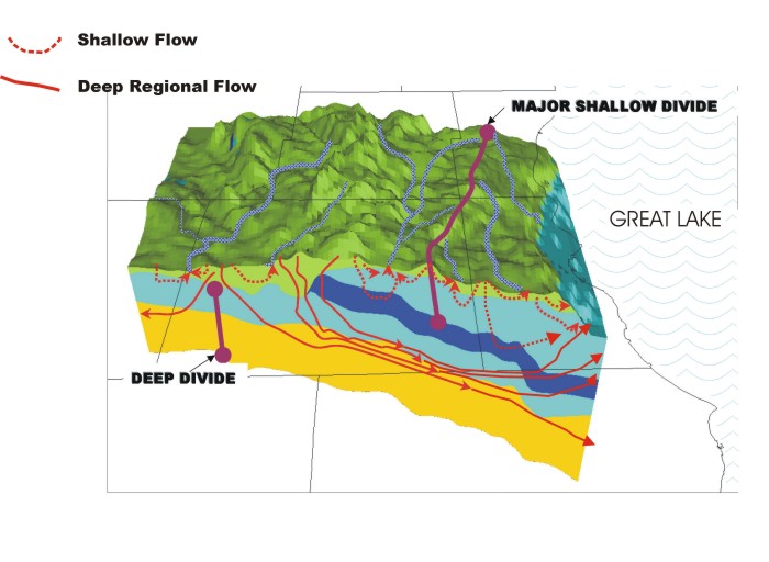
Deeper into the subsurface, it is often the case that ground water follows
longer paths and passes below local streams. In a deep aquifer separated
from the shallow part of the system by a low-permeability formation, it is
possible for the ground water to move tens of miles from a starting point
in a basin that is outside the Great Lakes surface-water divide to an
endpoint inside the Great Lakes basin or, more commonly, to a Great Lake
itself. The deep ground-water divide can be unrelated to the
surface-water divide and the region contributing ground water to the Great
Lakes can be much larger than the surface-water basin.
A second factor that controls the location of the ground-water
divides is pumping from wells. Pumping can shift ground-water divides from their
natural locations and even cause ground water that previously discharged to
a local stream to move across surface-water divides within the basin to
a regional pumping center outside the basin. Increases in pumping
gradually cause the ground water divides to shift, but they have no effect
on the surface-water divides.
return to top |