 SOURCES OF WATER TO WELLS SOURCES OF WATER TO WELLS
There
are two major sources of water pumped by wells:
- Decrease in discharge to surface water - streams and lakes
- Decrease in storage (lowered water levels)
After a long period of pumping around large pumping centers (often on the
order of decades), water levels can stop declining or decline very slowly, and
all of the water going to the wells is water that would have flowed to surface
water.
In general, pumping does not increase or decrease the amount of natural recharge,
although total recharge can be significantly increased by human activities such
as irrigation.
Sustainable yield
Sustainable yield is a socio-economic term, not
a scientific term. Sustainable yield is usually considered to be that rate of
pumping from wells for which the impact is acceptable; however what impact is “acceptable” is subjective.
There will always be a hydrologic effect of pumping from wells. In this sense,
there is no such thing as “safe yield”.
You can also ask: what is the source of water to wells in a particular area
of interest? In that case, besides decrease in storage and decrease in discharge
to surface water, there can also be increased ground-water inflow into the area
of interest from adjacent areas (or from underlying or overlying formations).
But this water also ultimately originates as storage release and reduced streamflow,
only outside the area of interest.
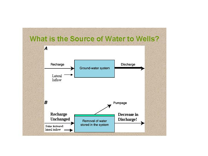
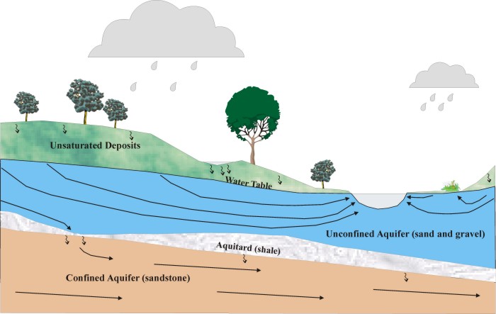
Pumping causes the flow system to change in many respects. It can increase
downward flow to a deep well, reduce flow to surface-water bodies, or even cause
water to move from a stream or lake to a well.
Thumbnail schematic sections showing diversion of ground
water to wells:
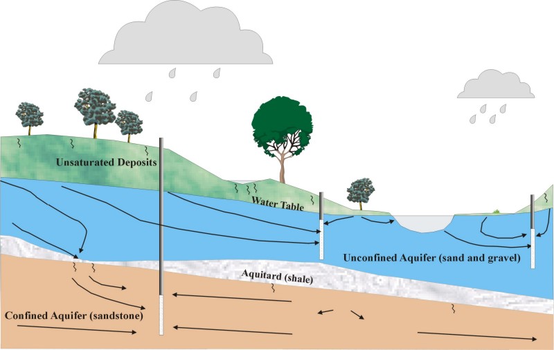
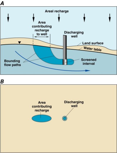
The land area contributing recharge to a discharge well,
sometimes called the
zone of contribution, is the surface area at the water table where water entering
the ground-water system eventually flows to the well. This contributing zone
must provide an amount of recharge that balances the amount of water being discharged
from the well. The lower the recharge rate, the greater is the area of contribution
for a fixed rate of pumping.
If a well reverses the natural pattern of ground-water
discharge and actually induces flow from the stream, then the zone at the land
surface contributing recharge to the well is smaller than it would be otherwise
because some of the well water is coming from a source other than recharge. In
certain areas (typically where coarse alluvial or outwash deposits surround rivers),
the supply to shallow wells can consist almost entirely of captured surface water
routed underground.
Computerized flow modeling is often used to map the areas from which ground
water circulates to surface-water bodies and/or wells. The model calculates the
three-dimensional paths that ground water follows from an initial location where
recharge enters the water table to a final point where it discharges from the
ground-water system. The combined recharge areas that feed a given discharge
feature (be it a stream, lake, or wetland) constitutes the zone of ground-water
contribution for that feature. Pumping wells compete for ground water with natural
discharge locations and change the size and shape of the natural zones of contribution.
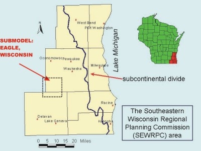
Here is an example where a computerized ground-water flow
model was used to evaluate the potential effect of proposed pumping wells on
shallow surface water discharge in southeastern Wisconsin.
The model area focuses on a part of Waukesha County around Eagle, Wisconsin:
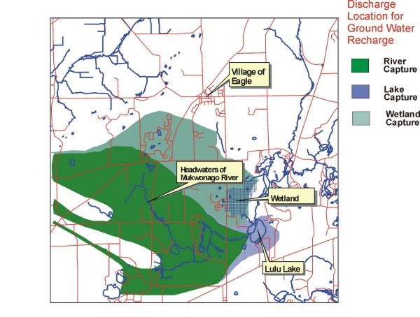
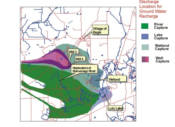
The model results show the predevelopment condition in
the absence of pumping (Figure A) and the simulated effect of two shallow wells
(Figure B).
In the absence of pumping, groundwater that recharges at the water table flows
either to a stream, a lake, or a wetland. The addition of wells shrinks the size
of the zones of contributions for the surface-water bodies. In particular, the
simulated pumping decreases the amount of ground water that flows to the wetland
by diverting ground water to the wells. It is possible to use these model results
to not only simulate how much water is lost to a wetland, but also to estimate
the change in the wetland water level.
More information on this example of a hydrogeologic and modeling study aimed
at investigating the sources of water to wells is available from the Wisconsin
Geological and Natural History Survey. The reference is:
Eaton, T.T. 2004. Construction of a groundwater flow model in the
area of the Village of Eagle based on refinement of a regional groundwater flow
model for southeastern Wisconsin: administrative report to the Southeastern
Wisconsin Regional Planning Commission, Wisconsin Geological and Natural History
Survey Open-File Report 04-XX (number to be assigned), 49 p.
To next concept --> Effect
of pumping from wells on ground-water divides
return to top
|

