| SCHEMATIC FLOW SYSTEM
Water cycles continuously between the earth's atmosphere, surface and subsurface.
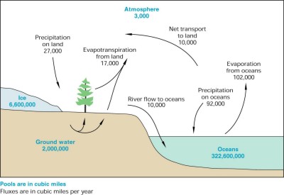
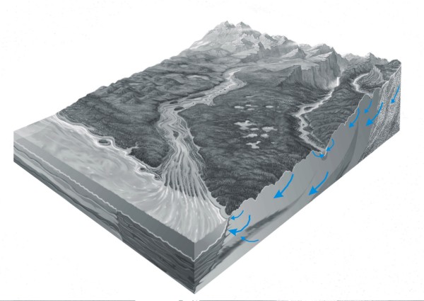
Hydrologic Cycle
A significant amount of water is stored in and flows through the subsurface as
ground water. Strictly speaking, ground water refers only to water below the
water table where the pores in loose sediment or lithified rock are fully saturated
with water. When the pores are saturated, the water is more free to move toward
streams or wells.
We call the circulation of ground water, from the water table where it is
recharged to its destination where it is discharged, the ground-water-flow system.
Most of the flow is lateral (that is, in a horizontal direction). However, there
is also a vertical component to the flow that can be especially important whereground
water enters the flow system, when it moves between parts of the flow system,
and where it exits the flow system. One way to understand typical ground-water
behavior is to consider flow that moves mostly in a single direction (say from
west to east) and draw flow lines along a vertical cross section aligned with
the direction of flow. Each of the following section plots is meant to emphasize
different aspects of ground-water flow system. In viewing them, keep in mind
that the vertical dimension is stretched (we say "exaggerated") to
bring into relief certain features.
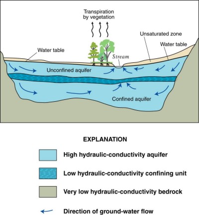
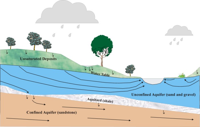
Unconfined vs. Confined Parts of Ground-Water Flow System:
Most ground water flows short distances (no more than one or two miles) from
where it enters the water table as recharge to where it exits the subsurface
as discharge. Recharge occurs over most of the land surface as water infiltrates
down through the unsaturated zone to the water table. The most common discharge
locations are streams, lakes, and wetlands; they occupy a relatively small proportion
of the landscape.
The bulk of ground-water flow in settings such as
the Great Lakes Basin occurs through permeable material lying at shallow depths
below the water table. However, some of the flow can move to deeper permeable
material separated from the shallow part of the flow system by less permeable
rock. The shallow material (often consisting of loose deposits laid down by rivers
or glaciers) is called an "unconfined
aquifer". The resistive layer (often consisting of lithified material like
shale) is called an "aquitard" or "confining bed". The deeper
layer (often consisting of lithified material like sandstone) is called a "confined
aquifer".
In the schematic section shown above, the ground
water in all three
"hydrostratigraphic" units forms a single flow system with a single
discharge point at a local stream. Although united in a single flow system, the
unconfined aquifer (whose top surface is the water table) and the confined aquifer
(whose top surface is the bottom of an aquitard) will react differently to stresses
such as pumping.
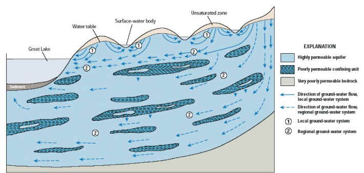
Local vs. Regional Ground-water Flow:
When ground-water systems are mapped at a large scale,
we find that while most of the water moves short distances to nearby streams
and lakes, some moves under local water bodies to more distant discharge features.
Such "regional
sinks" include
both natural features (e.g., a large water body) and manmade features (e.g.,
a deep, high-capacity well). In other words, although the "recharge area" or "capture
area" for most surface-water features is a small basin defined by local
topography, large bodies of water (and some wells), can receive some of their
water from distant basins. Consider any of the Great Lakes. The source of most
of the ground water that discharges to the Lake is precipitation and recharge
along its coastline, but there can be a component of deep tributary flow that
originates tens of miles inland from the coast.
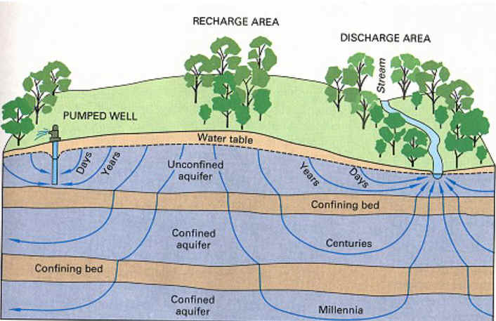
Exchange between Shallow and Deep Parts of a Ground-Water
Flow System:
It is often important to quantify how much of the ground
water circulates locally through shallow parts of the flow system as opposed
to how much circulates regionally through deeper parts of the system. It is also
useful to estimate the exchange between the shallow and deep parts of the system.
The schematic shows downward "leakage" from
an unconfined to confined aquifer. Most of the shallow flow is directed horizontally
toward a stream; the downward leakage represents a small fraction of the total
flow. The downward leakage is spatially focuses and has a strong vertical component;
most occurs where the resistive aquitard is thin or absent. Once in the deep
part of the flow system, the ground water moves largely in a horizontal direction
toward a regional sink.
Rapid vs. Slow Ground-Water Circulation:
Shallow flow to local sinks is relatively rapid, which
means that the time between when the water is recharged at the water table and
the time when it exits is typically on the order of months or years. Flow is
relatively rapid because distances tend to be short and hydraulic gradients tend
to be high. Deep flow to regional sinks can circulate for much longer times,
on the order of hundreds or thousands of years. In many areas around the Great
Lakes, multiple aquifers are stacked on top of one another, and the travel times
vary accordingly. Flow from a hillside to a shallow well open to glacial outwash
in the adjacent valley is much more rapid than flow across a series of resistive
units to a well open to a deep sandstone.
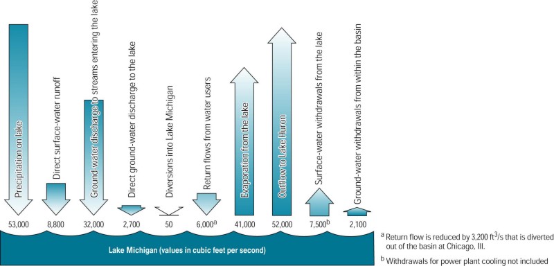
Each Great Lake is also a system with flows that enter and
exit. Consider Lake Michigan:
The biggest source of water to Lake Michigan is
the rain and snow that falls on it. Ground water is a relatively small component
of its "budget" if
you consider only the part that directly discharges across the lakebed near the
coastline. However, ground water is much more important if you consider the part
in the Lake budget played by tributary flow from rivers and streams. All these
surface-water bodies that empty into the Lake are fed by ground water. They are
the discharge locations for large and small ground-water flow systems everywhere
between the Lake Michigan coastline and the topographic divide that defines its
inland watershed. It is estimated that up to 80% of the water in streams tributary
to Lake Michigan originated as ground water. Streams in southeastern Wisconsin
receive somewhat less, about 40-50% of their flow from ground-water discharge.
For more information on the role of ground water
in the Great Lakes basin, see the USGS publication "The
Importance of Ground Water in the Great Lakes Region", Grannemann and
others, 2000, USGS Water-Resources Investigation Report 00-4008.
The components of the hydrologic cycle are connected. In particular, ground
water and surface water form a single resource:
This connection has an important consequence: when
cities develop, water that once discharged to streams and wetlands and lakes
is diverted to wells installed for water supply. This change from a natural ground-water
system to a developed system has occurred extensively within the Great Lakes
Basin. Shallow and deep wells have changed ground-water flow directions, have
moved the boundaries of ground-water systems, and have decreased the rates of
ground-water discharge to the surface.
To next Concept -- > Natural
recharge to ground water
return to top |