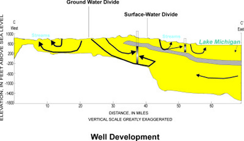
Ground-Water Divides Are Not Necessarily
the Same as the Great Lakes Watershed Divide.
- Most shallow flow discharges to local streams
- The Great Lakes watershed divide (i.e., the subcontinental divide)
also serves as a ground-water divide for shallow flow
- Most deep flow discharges to regional sinks
- The deep aquifer divide can be distant from the watershed divide
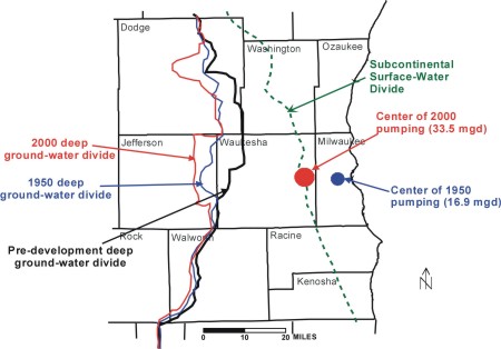
Ground-Water Divides Move In Response To Pumping.
- Pre-development, 1950, and 2000 ground-water divides for the sandstone aquifer
in the deep part of the flow system are in difference locations.
Ground Water That Once Flowed Toward Lake Michigan Is Now
Intercepted By Pumping And Diverted West Under The Surface-Water Divide, Where,
After Use, It Is Ultimately Discharged To Surface Water Within The Mississippi
River Basin.
- Over time, development on the Mississippi River Basin side of the subcontinental
divide has reversed deep flow patterns between Waukesha and Milwaukee.
Water From Lake Michigan Is NOT Pumped Out of Deep
Water Supply Wells in Southeastern Wisconsin.
- It is true that the direction of flow through the sandstone aquifer in the
deep part of the ground-water-flow system has reversed over the last 100 years
so that lake water that today moves from Lake Michigan into the underlying ground
water will require many hundreds, if not thousands, of years before it could
ever reach a well pumping in Waukesha County.
- Some water is entering deep wells in Waukesha County from the east. However,
it originated to the west as recharge in Waukesha or one of the surrounding Counties.
The ground-water flowed east toward the Lake over hundreds of years of travel,
and then curled back in response to pumping since around 1950:
- According to the model, 71% of the water that replenishes discharge from deep
wells in southeastern Wisconsin is ground water diverted from streams (captured
base flow) within the Mississippi River Basin even though the wells themselves
are located in the Lake Michigan ground-water basin. The remainder is from captured
base flow in the Lake Michigan Basin (6%), inland storage release (3%), storage
release below Lake Michigan (8%), water that once flow toward rocks under Lake
Michigan (8%) and water flowing out of Lake Michigan itself (only 4%).
Even Though Lake Michigan Itself Is A Neglible Source
of Water Directly Pumped From Wells In Southeastern Wisconsin, It Is Also True
That Pumping Has Reduced The Amount of Ground Water That Enters The Lake.
- Compared to predevelopment, pumping has reduced the amount of ground water
that flows directly to the Lake across the coastline or flows indirectly to it
as part of river discharge. Calculations indicate the reduction in direct and
indirect ground-water discharge to the lake is on the order of 8.5%. Some of
this diverted water is eventually returned to the Lake through sewers and water-treatment
plants, but the location, timing, and quality of the return flow is different
than what it was under natural conditions.
- While the reduction in lake-bound ground-water discharge due to pumping
is not an insignificant part of the total discharge from southeastern Wisconsin
, it is very small in absolute terms when compared to the other items in the
budget of the Lake such as precipitation and total inflow from rivers.
return to top |