| |
In Wisconsin, 70% of residents and 97% of communities rely on groundwater
as their drinking water source. Protecting groundwater from contamination and
overuse is vital to the health of Wisconsin’s people, ecosystems, communities,
and economy.
Many Wisconsin communities are facing groundwater
stress in various forms and can benefit or have benefitted from groundwater planning.
For example:
- Private well testing and drinking water education
programs in Iowa
County led to greater awareness, installation of household water
filters, greater use of the county's well abandonment program and participation
in a comprehensive groundwater study to guide local land use planning.
- Chemical contamination of a municipal well in the
City
of Waupaca by a dry cleaning business led to reduced pumping capacity and
the city council and local businesses adopted multiple water conservation measures.
-
To facilitate the economic revival of its rural communities by providing incentives
for young farmers to engage in high-margin organic farming businesses, Woodbury
County, Iowa provides a full rebate of real property taxes for five years
to anyone that converts to organic farming techniques that comply with the USDA
standards.
-
High
nitrate levels in a municipal well in the City
of Chippewa Falls led the county
board to adopt a county-wide wellhead protection ordinance.
- Rapid population growth in Washington County led
the Town
of Richfield to develop
a water budget for the town and then adopt a groundwater protection ordinance
that applies to water use of new development.
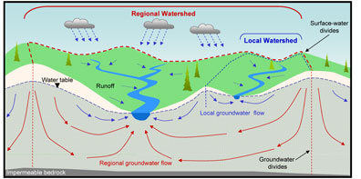
Groundwater originates as precipitation that soaks
into the land until it reaches a saturated zone underground called the water
table.
As the first figure shows, it then generally moves
toward surface water bodies, such as lakes, streams, and wetlands. In some places,
however, the system works the other way around, and groundwater is recharged
from surface water sources.
Wisconsin has abundant quantities of high-quality
groundwater, but its quality and quantity depend on our actions on the land
surface. Most groundwater contaminants originate on the land surface and are
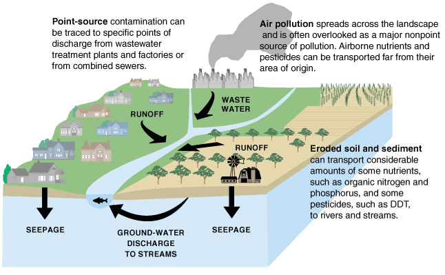
carried downward by rain and melting snow. As the second figure shows, numerous
everyday activities can contaminate groundwater, and contaminated groundwater
is expensive and difficult or impossible to clean. In addition, paving over or
otherwise covering groundwater recharge areas can lead to groundwater quantity
problems in the future.

Figure showing potential
sources of groundwater contamination.
Image provided by USGS.
Good planning can separate
possible polluting sources from groundwater resources, protect recharge areas,
and ensure a safe and abundant supply of groundwater for your community’s
future.
MORE INFORMATION ON GROUNDWATER
GROUNDWATER IN COMPREHENSIVE PLANNING
- Groundwater
and its Role in Comprehensive Planning, Comprehensive Planning and Groundwater
Fact Sheet 1, by the Wisconsin Groundwater Coordinating Council, 4 pp.
This fact sheet provides some background information on groundwater and discusses
its relation to comprehensive planning.
- Resources
to help you protect your drinking water supply, Comprehensive Planning and
Groundwater Fact Sheet 2, by the Wisconsin Groundwater Coordinating Council,
4 pp.
This fact sheet describes what information is needed to address groundwater in
comprehensive plans and where to go to find that information.
- Residential
Development and Groundwater Resources, Comprehensive Planning and Groundwater
Fact Sheet 3, by the Wisconsin Groundwater Coordinating Council, 4 pp.
This fact sheet examines the relationship between residential development, particularly
development of new subdivisions, and the groundwater resource. It also discusses
ways in which impacts can be minimized.
WISCONSIN GROUNDWATER BASICS
- Groundwater:
Wisconsin’s Buried Treasure by Wisconsin Department
of Natural Resources,
2006.
This web site provides easy-to-read information about Wisconsin’s groundwater
aquifers, groundwater use, groundwater threats, groundwater protection and sources
of additional information.
- A
Water Science Primer, in Wisconsin’s waters, A confluence of perspectives by R.J.
Hunt 2003. Wisconsin Academy of Sciences, Arts, and Letters, Transactions
Volume 90, Edited by Curt Meine, 178 pp.
This primer discusses overarching concepts
about water resources including their unique properties, limits, connectedness
with one another and the landscape, and moving and changing nature.
- Groundwater quantity resources by the Groundwater Coordinating Council.
This list of reports and electronic documents related to groundwater quantity
was developed to address the current focus and awareness of groundwater quantity
issues in Wisconsin. A good place to begin learning about groundwater quantity
concerns in Wisconsin is the two-page publication Groundwater
Drawdown.
- Wisconsinís Groundwater Directory,
by the Center for Watershed Science and Education, UW Stevens
Point, 2006, 17
pp.
This web site describes groundwater activities of state and federal agencies
and provides contact information.
- Groundwater
and Surface Water: A Single Resource by U.S. Geological
Survey, 1998, 87
pp.
This document describes the interaction of groundwater and surface water, in
terms of both quantity and quality, as applied to a variety of landscapes across
the Nation. Its intent is to help other Federal, State, and local agencies build
a firm scientific foundation for policies governing the management and protection
of aquifers and watersheds.
GEOLOGIC AND HYDROLOGIC MAPS
- Geologic
maps by county, region and entire state, by the UW Extension, Wisconsin Geological and Natural History Survey.
This web site identifies publications containing geologic maps of areas of Wisconsin.
- Water
table maps by the UW Extension,
Wisconsin Geological and Natural History Survey.
This web site identifies publications
containing water-table maps by county.
- Hydrologic
Investigations Atlas series by the US Geological Survey, 12 atlases.
This series uses colored maps, figures, and diagrams to show the hydrologic systems
in the major river basins of the state. Subjects include the general physical
setting, the availability and natural quality of groundwater and surface water,
stream flows, water use, and other hydrologic information. These atlases are
not available electronically, but most are available from the WGNHS. See page
45 at the link above.
GEOLOGIC AND HYDROLOGIC DATA AND INFORMATION
-
Ground Water Observation Network
for Wisconsin, by the USGS Wisconsin
Water Science Center and the UW Extension, Wisconsin Geological and Natural History
Survey.
The Ground-Water Observation Network monitors water levels in approximately
100 wells throughout Wisconsin, and archives their historical water-level data.
-
USGS Ground-Water
Data for Wisconsin, by the U.S. Geological Survey.
The USGS National Water Information
System (NWIS) contains extensive water data for the Nation. Public access to
many of these data is provided via NWISWeb.
-
Geology
of Wisconsin, Survey of 1873-1879, by T.C. Chamberlin, in
the Ecology and Natural Resources Collection of the University of Wisconsin Digital
Collections, 4 volumes.
The Wisconsin Legislature mandated a fifth incarnation
of the state geological survey in 1873 to conduct a “complete geological,
mineralogical and agricultural survey of the state”. The results of this
survey is contained in these 4 volumes.
HYDROLOGIC RESEARCH AND MODELING
- Current
hydrologic research projects,
by the UW Extension, Wisconsin Geological and Natural History Survey.
This web
site describes recent and current hydrologic research projects and available
products.
-
Current hydrologic
research projects, by the USGS Wisconsin Water
Science Center.
This web site describes recent and current hydrologic research
projects and available products.
- Current
hydrologic research projects, by the University of Wisconsin
Water Resources Institute.
This web site provides access to publications based
on research supported by or through the Wisconsin Water Resources Institute.
-
Current hydrologic
research projects, by the Wisconsin Groundwater
Coordinating Council.
This web site provides information about the Groundwater
Coordinating Council and access to results of research supported by participating
state agencies.
WATER QUANTITY LEGISLATION
return
to top
|


