 SURFACE-WATER AND NATURAL GROUND-WATER
DIVIDES IN SOUTHEASTERN WISCONSIN SURFACE-WATER AND NATURAL GROUND-WATER
DIVIDES IN SOUTHEASTERN WISCONSIN
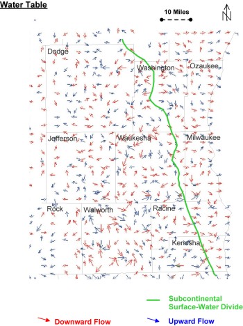
Local topography and arrangement of surface-water bodies control shallow ground-water
flow in southeastern Wisconsin. The variations in lateral direction of flow and
the alteration between upward and downward flow formed many relatively small-scale
flow systems that discharged to local water bodies (streams, wetlands, lakes,
seeps). These flow lines are relatively short (generally less than 2 miles);
even along the subcontinental divide flow directions are determined by the relative
location of many small surface-water bodies.
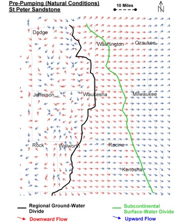
The ground-water flow pattern is much different in the deep sandstone aquifer
than it is at the water table. Flow directions shown for the St. Peter Formation
in the figure below are representative of flow in most of the deeper sandstone
units. The St. Peter is the top sandstone layer.
Prior to development under natural conditions, small-scale flow systems characterized
the flow in the sandstone aquifer toward the west (indicated by the variety of
arrow directions) while regional flow was dominant to the east (indicated by
uniform arrow directions). A ground-water divide separated the two areas. This
deep ground-water divide is closely related to the western edge of the Maquoketa
shale and marks the transition from a confined to unconfined flow system.
Note that the ground-water divide was distant from the subcontinental surface-water
divide marking the edge of the Lake Michigan basin. For example in central Waukesha
County, the deep ground-water divide was 18 miles west of the subcontinental
divide. West of the divide, deep ground water interacted freely with the shallow
part of the flow system, while deep ground water east of the divide flowed over
long distances toward Lake Michigan.
Thus, under natural, pre-development conditions in southeastern Wisconsin,
the Great Lakes basin with respect to tributary ground water was much larger
than the basin with respect to tributary surface water. Under pumping conditions
the discrepancy became even larger.
The pattern of upward and downward flow in the St. Peter sandstone was distinctive.
West of the regional ground-water divide, the vertical direction changed over
short distances as leakage from the shallow part of the flow system was carried
downward into the sandstone aquifer, circulated laterally, and then moved upward
to local discharge locations. East of the divide, the pattern is much more uniform.
Ground water moved eastward and downward deeper into the sandstone aquifer, traveled
long distances laterally within the aquifer, and eventually tilted upward toward
the single ground-water sink for the region - Lake Michigan. Under pumping conditions,
this natural pattern is disrupted.
return to top |

