|
 NATURAL DISCHARGE OF GROUND WATER IN SOUTHEASTERN
WISCONSIN NATURAL DISCHARGE OF GROUND WATER IN SOUTHEASTERN
WISCONSIN
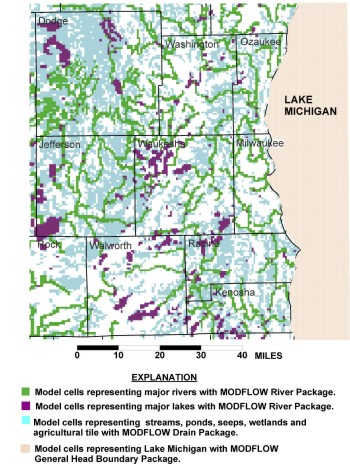
The surface-water bodies in southeastern Wisconsin
consists of rivers, streams, headwater creeks, lakes, ponds, wetlands, seeps,
springs, and agricultural tile as well as Lake Michigan. Together they produce
a relatively dense network:
The model incorporates this network using three types of input, one for Lake
Michigan, one for major rivers, streams, and lakes, and one for secondary features
such as wetlands and agricultural tile.
All these features are available in the model
as potential locations for ground-water discharge. Under the influence of pumping,
Lake Michigan and the major water bodies are also available as sources of ground-water
recharge to wells.
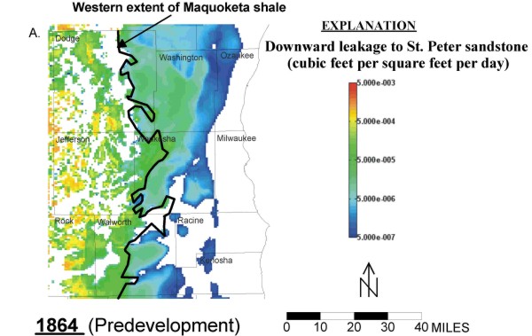
Exchange between shallow and deep parts of flow system:
When ground water leaks downward from an unconfined aquifer to an underlying
confined aquifer, or leaks upward from a deep, hydrogeologic unit to a regional
sink, then the exchange can be considered a kind of internal discharge within
the flow system. For southeastern Wisconsin, we are particularly interested in
the vertical exchange that occurs across the top of the sandstone units that
represent the main regional aquifer for the area. The uppermost sandstone unit
is the St. Peter Formation; it corresponds to the most shallow sandstone unit
stippled in the block diagram shown below:
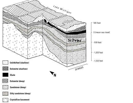
Block diagram of shallow and deep rock
units in southeastern Wisconsin
(source: modified from Wisconsin Geological and Natural
History Survey Open-File Report 2004-01)
Under natural conditions, both downward flow to the St. Peter and upward flow
from the St. Peter occurs. The complexity of the pattern is shown in the following
plot. White areas represent locations where there is upward flow or no vertical
exchange at all. Colored areas represent locations of downward leakage, where
blue/green zones indicate low rates of leakage and red/yellow zones represent
high rates of leakage.
There are three points to emphasize:
- In the absence of pumping, upward flow occurred in the
sandstone toward the shallow part of the flow system all along the Lake Michigan
coastline as well as under the Lake. That is, the Lake acted as a strong regional
sink.
- There was continuous zone of downward leakage along a
belt from north to south in the middle of southeastern Wisconsin, with higher
rates occurring where the Maquoketa shale is absent.
- Zones of upward and downward flow intermingled in the
western part of the study area. This pattern indicates that ground water in the
St. Peter sandstone exchanged freely with shallower ground water and discharged
locally to surface water bodies. The relatively high rates of downward leakage
suggest that a large part of the recharge to the water table circulated to the
sandstone before discharging back to the surface.
return to top |